Jonestown elevation
Jonestown (Pennsylvania, Lebanon County), United States elevation is 148 meters and Jonestown elevation in feet is 486 ft above sea level [src 1]. Jonestown is a populated place (feature code) with elevation that is 131 meters (430 ft) smaller than average city elevation in United States.
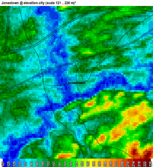
Below is the Elevation map of Jonestown, which displays elevation range with different colors. Scale of the first map is from 121 to 226 m (397 to 741 ft) with average elevation of 150.6 meters (=494 ft) [note 1]
These maps also provides idea of topography and contour of this city, they are displayed at different zoom levels. More info about maps, scale and edge coordinates you can find below images.
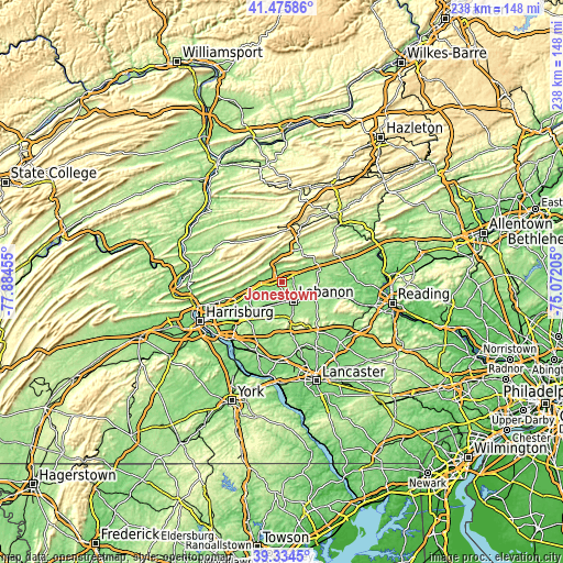
| \ | Map #1 | Topo.Map |
| Scale [m] | 121..226 m | × |
| Scale [ft] | 397..741 ft | × |
| Average | 150.6 m = 494 ft | × |
| Width | 7.44 km = 4.6 mi | 238.1 km = 147.9 mi |
| Height | 7.44 km = 4.6 mi | 238.1 km = 147.9 mi |
| ↑Max Latitude | 40.447151° | 41.47586° |
| Latitude at center | 40.4137° | 40.4137° |
| ↓Min Latitude | 40.380232° | 39.3345° |
| ← Min Longitude | -76.522245° | -77.88455° |
| Longitude center | -76.4783° | -76.4783° |
| →Max Longitude | -76.434355° | -75.07205° |
Nearby cities:
Cities around Jonestown sort by population:
• Lebanon elevation 147 m
9.9 km,  144°
144°
• Palmyra 143 m
15.2 km,  219°
219°
• Annville 126 m
9.9 km,  198°
198°
• Cornwall 194 m
16.7 km,  158°
158°
• Myerstown 149 m
15.5 km,  106°
106°
• Pleasant Hill 141 m
9.2 km, 160°
• Sand Hill 190 m
7.2 km,  146°
146°
• Lebanon South 161 m
11.3 km, 147°
• Cleona 140 m
8.5 km,  178°
178°
• Avon 153 m
10.6 km, 135°
• Fredericksburg 146 m
5.4 km,  51°
51°
• Hebron 154 m
10.7 km, 141°
Multilingual:
 En español:
Jonestown elevación 148 m.
 En France:
Jonestown élévation 148 m.
 Auf Deutsch:
Jonestown höhe über dem Meeresspiegel ist 148 m.

Sources and notes:
- [note 1] Map square and city borders are not equal. Map elevation data is calculated only from area inside that square.
- [src 1] Elevation data from geonames database provided with same terms of usage.
- [src 2] The elevation map of Jonestown is generated using elevation data from NASA's 3 arcsec (90m) resolution SRTM data.
- [src 3] Base (background) map © OpenStreetMap contributors tiles are generated by Geofabrik and OpenTopoMap.
Copyright & License:
This Jonestown Elevation Map is licensed under CC BY-SA. You may reuse any part from this page, if you give a proper credit by linking to this URL:
 More info on terms of use page.