Elizabethville elevation
Elizabethville (Pennsylvania, Dauphin County), United States elevation is 206 meters and Elizabethville elevation in feet is 676 ft above sea level [src 1]. Elizabethville is a populated place (feature code) with elevation that is 73 meters (240 ft) smaller than average city elevation in United States.
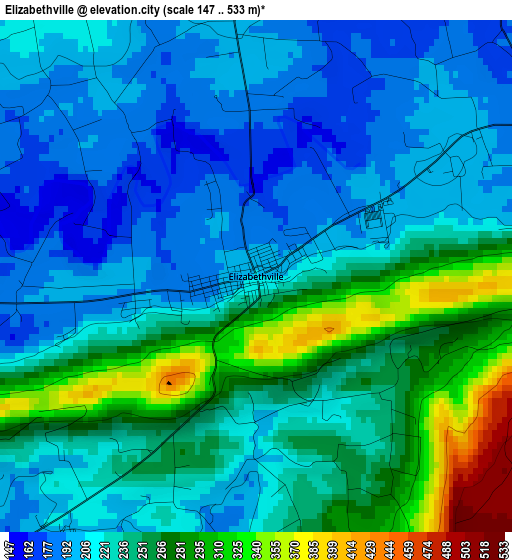
Below is the Elevation map of Elizabethville, which displays elevation range with different colors. Scale of the first map is from 147 to 533 m (482 to 1749 ft) with average elevation of 235.1 meters (=771 ft) [note 1]
These maps also provides idea of topography and contour of this city, they are displayed at different zoom levels. More info about maps, scale and edge coordinates you can find below images.
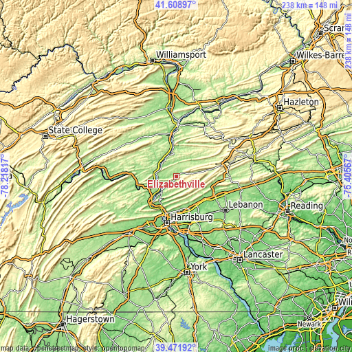
| \ | Map #1 | Topo.Map |
| Scale [m] | 147..533 m | × |
| Scale [ft] | 482..1749 ft | × |
| Average | 235.1 m = 771 ft | × |
| Width | 7.43 km = 4.6 mi | 237.6 km = 147.6 mi |
| Height | 7.43 km = 4.6 mi | 237.6 km = 147.6 mi |
| ↑Max Latitude | 40.582354° | 41.60897° |
| Latitude at center | 40.54897° | 40.54897° |
| ↓Min Latitude | 40.51557° | 39.47192° |
| ← Min Longitude | -76.855865° | -78.21817° |
| Longitude center | -76.81192° | -76.81192° |
| →Max Longitude | -76.767975° | -75.40567° |
Nearby cities:
Cities around Elizabethville sort by population:
• Linglestown elevation 167 m
24 km,  175°
175°
• Paxtonia 160 m
25.8 km, 176°
• Skyline View 157 m
24.4 km,  162°
162°
• Lawrence Park 153 m
22.6 km, 177°
• Matamoras 194 m
15.9 km,  220°
220°
• Millersburg 130 m
12.6 km,  265°
265°
• Marysville 115 m
25 km,  203°
203°
• Lykens 215 m
9.6 km,  78°
78°
• Valley View 246 m
25.4 km,  64°
64°
• Duncannon 112 m
24.5 km,  226°
226°
• Williamstown 227 m
16.8 km, 78°
• Tower City 242 m
22.4 km, 78°
Multilingual:
 En español:
Elizabethville elevación 206 m.
 En France:
Elizabethville élévation 206 m.
 Auf Deutsch:
Elizabethville höhe über dem Meeresspiegel ist 206 m.

Sources and notes:
- [note 1] Map square and city borders are not equal. Map elevation data is calculated only from area inside that square.
- [src 1] Elevation data from geonames database provided with same terms of usage.
- [src 2] The elevation map of Elizabethville is generated using elevation data from NASA's 3 arcsec (90m) resolution SRTM data.
- [src 3] Base (background) map © OpenStreetMap contributors tiles are generated by Geofabrik and OpenTopoMap.
Copyright & License:
This Elizabethville Elevation Map is licensed under CC BY-SA. You may reuse any part from this page, if you give a proper credit by linking to this URL:
 More info on terms of use page.