Westfield elevation
Westfield (Pennsylvania, Tioga County), United States elevation is 423 meters and Westfield elevation in feet is 1388 ft above sea level [src 1]. Westfield is a populated place (feature code) with elevation that is 144 meters (472 ft) bigger than average city elevation in United States.
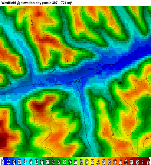
Below is the Elevation map of Westfield, which displays elevation range with different colors. Scale of the first map is from 397 to 724 m (1302 to 2375 ft) with average elevation of 531.9 meters (=1745 ft) [note 1]
These maps also provides idea of topography and contour of this city, they are displayed at different zoom levels. More info about maps, scale and edge coordinates you can find below images.
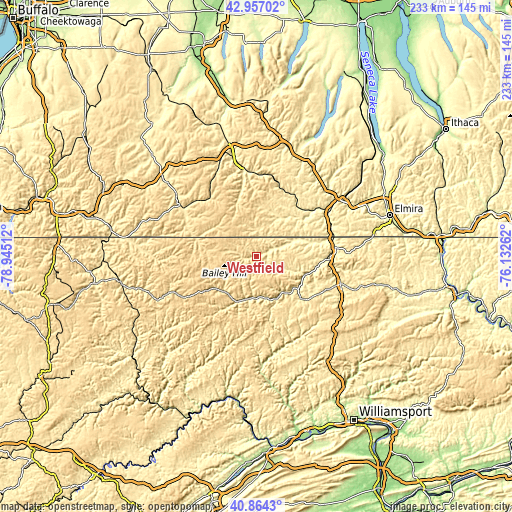
| \ | Map #1 | Topo.Map |
| Scale [m] | 397..724 m | × |
| Scale [ft] | 1302..2375 ft | × |
| Average | 531.9 m = 1745 ft | × |
| Width | 7.27 km = 4.5 mi | 232.7 km = 144.6 mi |
| Height | 7.27 km = 4.5 mi | 232.7 km = 144.6 mi |
| ↑Max Latitude | 41.951931° | 42.95702° |
| Latitude at center | 41.91924° | 41.91924° |
| ↓Min Latitude | 41.886532° | 40.8643° |
| ← Min Longitude | -77.582815° | -78.94512° |
| Longitude center | -77.53887° | -77.53887° |
| →Max Longitude | -77.494925° | -76.13262° |
Nearby cities:
Cities around Westfield sort by population:
• Wellsville elevation 461 m
40.6 km,  303°
303°
• Gang Mills 290 m
43.4 km,  54°
54°
• Alfred 542 m
42.6 km,  330°
330°
• Mansfield 352 m
40.2 km,  108°
108°
• Wellsboro 401 m
27.4 km,  133°
133°
• Coudersport 507 m
43 km,  248°
248°
• Canisteo 348 m
39.4 km,  351°
351°
• Lindley 309 m
35.2 km,  69°
69°
• Elkland 348 m
20.3 km, 68°
• Addison 304 m
32.4 km, 51°
• Galeton 400 m
22.4 km,  202°
202°
• Andover 509 m
33.8 km,  321°
321°
Multilingual:
 En español:
Westfield elevación 423 m.
 En France:
Westfield élévation 423 m.
 Auf Deutsch:
Westfield höhe über dem Meeresspiegel ist 423 m.

Sources and notes:
- [note 1] Map square and city borders are not equal. Map elevation data is calculated only from area inside that square.
- [src 1] Elevation data from geonames database provided with same terms of usage.
- [src 2] The elevation map of Westfield is generated using elevation data from NASA's 3 arcsec (90m) resolution SRTM data.
- [src 3] Base (background) map © OpenStreetMap contributors tiles are generated by Geofabrik and OpenTopoMap.
Copyright & License:
This Westfield Elevation Map is licensed under CC BY-SA. You may reuse any part from this page, if you give a proper credit by linking to this URL:
 More info on terms of use page.