Wellsboro elevation
Wellsboro (Pennsylvania, Tioga County), United States elevation is 401 meters and Wellsboro elevation in feet is 1316 ft above sea level [src 1]. Wellsboro is a seat of a second-order administrative division (feature code) with elevation that is 122 meters (400 ft) bigger than average city elevation in United States.
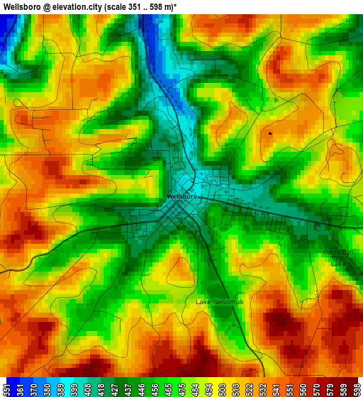
Below is the Elevation map of Wellsboro, which displays elevation range with different colors. Scale of the first map is from 351 to 598 m (1152 to 1962 ft) with average elevation of 486.2 meters (=1595 ft) [note 1]
These maps also provides idea of topography and contour of this city, they are displayed at different zoom levels. More info about maps, scale and edge coordinates you can find below images.
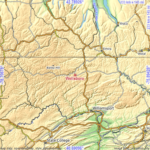
| \ | Map #1 | Topo.Map |
| Scale [m] | 351..598 m | × |
| Scale [ft] | 1152..1962 ft | × |
| Average | 486.2 m = 1595 ft | × |
| Width | 7.29 km = 4.5 mi | 233.3 km = 145 mi |
| Height | 7.29 km = 4.5 mi | 233.3 km = 145 mi |
| ↑Max Latitude | 41.781458° | 42.78926° |
| Latitude at center | 41.74868° | 41.74868° |
| ↓Min Latitude | 41.715885° | 40.69096° |
| ← Min Longitude | -77.344475° | -78.70678° |
| Longitude center | -77.30053° | -77.30053° |
| →Max Longitude | -77.256585° | -75.89428° |
Nearby cities:
Cities around Wellsboro sort by population:
• Corning elevation 289 m
48.3 km,  24°
24°
• Gang Mills 290 m
46.9 km, 19°
• Mansfield 352 m
19.6 km,  70°
70°
• Lindley 309 m
33.8 km, 23°
• Canton 377 m
38.5 km,  105°
105°
• Elkland 348 m
26.4 km,  358°
358°
• Addison 304 m
39.8 km,  8°
8°
• Blossburg 409 m
21.1 km, 111°
• Troy 338 m
42.7 km,  84°
84°
• South Corning 293 m
46.9 km,  27°
27°
• Galeton 400 m
28.4 km,  266°
266°
• Westfield 423 m
27.4 km,  313°
313°
Multilingual:
 En español:
Wellsboro elevación 401 m.
 En France:
Wellsboro élévation 401 m.
 Auf Deutsch:
Wellsboro höhe über dem Meeresspiegel ist 401 m.

Sources and notes:
- [note 1] Map square and city borders are not equal. Map elevation data is calculated only from area inside that square.
- [src 1] Elevation data from geonames database provided with same terms of usage.
- [src 2] The elevation map of Wellsboro is generated using elevation data from NASA's 3 arcsec (90m) resolution SRTM data.
- [src 3] Base (background) map © OpenStreetMap contributors tiles are generated by Geofabrik and OpenTopoMap.
Copyright & License:
This Wellsboro Elevation Map is licensed under CC BY-SA. You may reuse any part from this page, if you give a proper credit by linking to this URL:
 More info on terms of use page.