Towamensing Trails elevation
Towamensing Trails (Pennsylvania, Carbon County), United States elevation is 502 meters and Towamensing Trails elevation in feet is 1647 ft above sea level [src 1]. Towamensing Trails is a populated place (feature code) with elevation that is 223 meters (732 ft) bigger than average city elevation in United States.
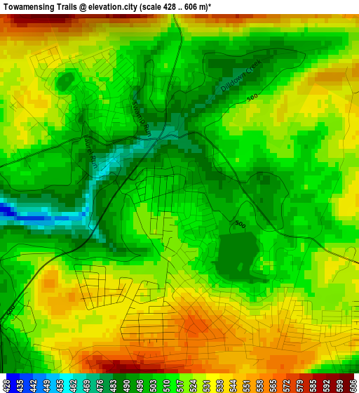
Below is the Elevation map of Towamensing Trails, which displays elevation range with different colors. Scale of the first map is from 428 to 606 m (1404 to 1988 ft) with average elevation of 518.4 meters (=1701 ft) [note 1]
These maps also provides idea of topography and contour of this city, they are displayed at different zoom levels. More info about maps, scale and edge coordinates you can find below images.
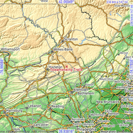
| \ | Map #1 | Topo.Map |
| Scale [m] | 428..606 m | × |
| Scale [ft] | 1404..1988 ft | × |
| Average | 518.4 m = 1701 ft | × |
| Width | 7.37 km = 4.6 mi | 236 km = 146.6 mi |
| Height | 7.37 km = 4.6 mi | 236 km = 146.6 mi |
| ↑Max Latitude | 41.041024° | 42.06049° |
| Latitude at center | 41.00787° | 41.00787° |
| ↓Min Latitude | 40.9747° | 39.93816° |
| ← Min Longitude | -75.628575° | -76.99088° |
| Longitude center | -75.58463° | -75.58463° |
| →Max Longitude | -75.540685° | -74.17838° |
Nearby cities:
Cities around Towamensing Trails sort by population:
• Sierra View elevation 579 m
10.6 km,  87°
87°
• Jim Thorpe 223 m
19.2 km,  220°
220°
• Indian Mountain Lake 548 m
6.4 km, 94°
• Emerald Lakes 615 m
16.5 km,  57°
57°
• Weatherly 344 m
21.8 km,  250°
250°
• Sun Valley 363 m
10.4 km,  106°
106°
• Sun Valley 578 m
9.7 km, 87°
• Effort 240 m
14.7 km,  121°
121°
• Brodheadsville 229 m
18.5 km, 120°
• Weissport East 190 m
20.8 km,  204°
204°
• Pocono Pines 558 m
15.5 km,  44°
44°
• White Haven 354 m
16.9 km,  290°
290°
Multilingual:
 En español:
Towamensing Trails elevación 502 m.
 En France:
Towamensing Trails élévation 502 m.
 Auf Deutsch:
Towamensing Trails höhe über dem Meeresspiegel ist 502 m.
 На русском:
Towamensing Trails высота над уровнем моря 502 м
Sources and notes:
- [note 1] Map square and city borders are not equal. Map elevation data is calculated only from area inside that square.
- [src 1] Elevation data from geonames database provided with same terms of usage.
- [src 2] The elevation map of Towamensing Trails is generated using elevation data from NASA's 3 arcsec (90m) resolution SRTM data.
- [src 3] Base (background) map © OpenStreetMap contributors tiles are generated by Geofabrik and OpenTopoMap.
Copyright & License:
This Towamensing Trails Elevation Map is licensed under CC BY-SA. You may reuse any part from this page, if you give a proper credit by linking to this URL:
 More info on terms of use page.