Jim Thorpe elevation
Jim Thorpe (Pennsylvania, Carbon County), United States elevation is 223 meters and Jim Thorpe elevation in feet is 732 ft above sea level [src 1]. Jim Thorpe is a seat of a second-order administrative division (feature code) with elevation that is 56 meters (184 ft) smaller than average city elevation in United States.
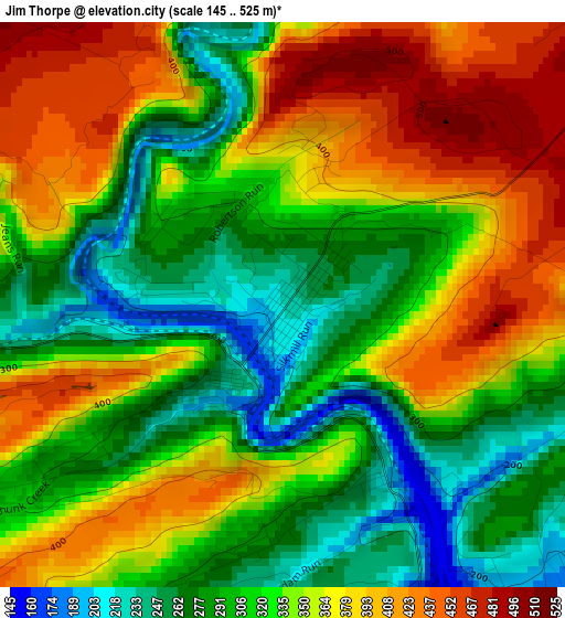
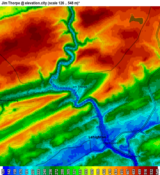
Below is the Elevation map of Jim Thorpe, which displays elevation range with different colors. Scale of the first map is from 145 to 525 m (476 to 1722 ft) with average elevation of 336.3 meters (=1103 ft) [note 1]
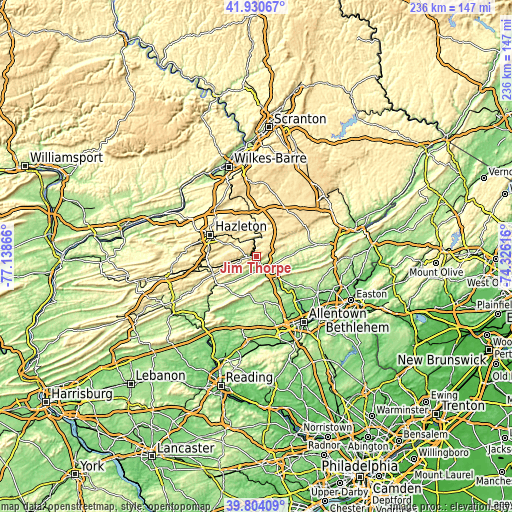
These maps also provides idea of topography and contour of this city, they are displayed at different zoom levels. More info about maps, scale and edge coordinates you can find below images.
| \ | Map #1 | Map #2 | Topo.Map |
| Scale [m] | 145..525 m | 126..548 m | × |
| Scale [ft] | 476..1722 ft | 413..1798 ft | × |
| Average | 336.3 m = 1103 ft | 350.4 m = 1150 ft | × |
| Width | 7.39 km = 4.6 mi | 14.78 km = 9.2 mi | 236.5 km = 147 mi |
| Height | 7.39 km = 4.6 mi | 14.78 km = 9.2 mi | 236.4 km = 146.9 mi |
| ↑Max Latitude | 40.90914° | 40.942343° | 41.93067° |
| Latitude at center | 40.87592° | 40.87592° | 40.87592° |
| ↓Min Latitude | 40.842683° | 40.80943° | 39.80409° |
| ← Min Longitude | -75.776355° | -75.820301° | -77.13866° |
| Longitude center | -75.73241° | -75.73241° | -75.73241° |
| →Max Longitude | -75.688465° | -75.644519° | -74.32616° |
Nearby cities:
Cities around Jim Thorpe sort by population:
• Lehighton elevation 177 m
4.9 km,  161°
161°
• Palmerton 126 m
13.1 km,  129°
129°
• Slatington 154 m
17.4 km,  144°
144°
• Lansford 351 m
13.5 km,  248°
248°
• Nesquehoning 256 m
6.7 km,  259°
259°
• Summit Hill 464 m
13 km,  244°
244°
• Weatherly 344 m
11 km,  311°
311°
• Towamensing Trails 502 m
19.2 km,  40°
40°
• Coaldale 320 m
15.8 km, 248°
• Walnutport 118 m
17.6 km, 140°
• Weissport East 190 m
5.8 km, 138°
• Oakdale 493 m
20.4 km, 309°
Multilingual:
 En español:
Jim Thorpe elevación 223 m.
 En France:
Jim Thorpe élévation 223 m.
 Auf Deutsch:
Jim Thorpe höhe über dem Meeresspiegel ist 223 m.

Sources and notes:
- [note 1] Map square and city borders are not equal. Map elevation data is calculated only from area inside that square.
- [src 1] Elevation data from geonames database provided with same terms of usage.
- [src 2] The elevation map of Jim Thorpe is generated using elevation data from NASA's 3 arcsec (90m) resolution SRTM data.
- [src 3] Base (background) map © OpenStreetMap contributors tiles are generated by Geofabrik and OpenTopoMap.
Copyright & License:
This Jim Thorpe Elevation Map is licensed under CC BY-SA. You may reuse any part from this page, if you give a proper credit by linking to this URL:
 More info on terms of use page.