Palmerton elevation
Palmerton (Pennsylvania, Carbon County), United States elevation is 126 meters and Palmerton elevation in feet is 413 ft above sea level [src 1]. Palmerton is a populated place (feature code) with elevation that is 153 meters (502 ft) smaller than average city elevation in United States.
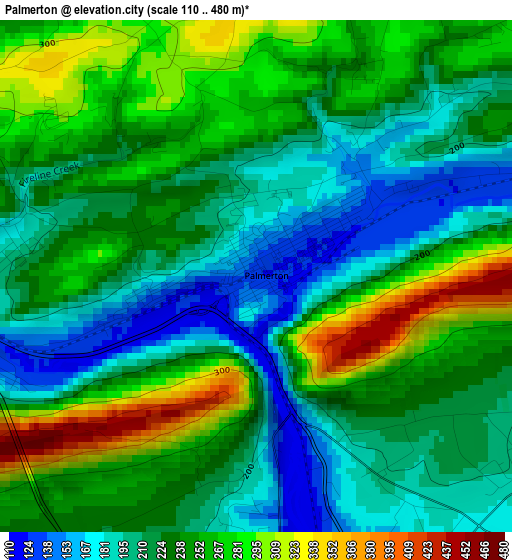
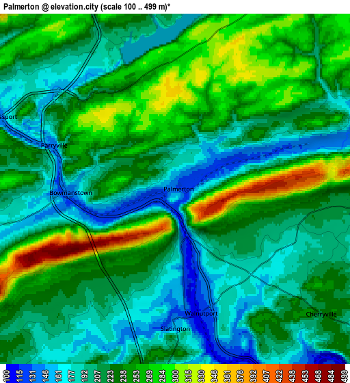
Below is the Elevation map of Palmerton, which displays elevation range with different colors. Scale of the first map is from 110 to 480 m (361 to 1575 ft) with average elevation of 234 meters (=768 ft) [note 1]
These maps also provides idea of topography and contour of this city, they are displayed at different zoom levels. More info about maps, scale and edge coordinates you can find below images.
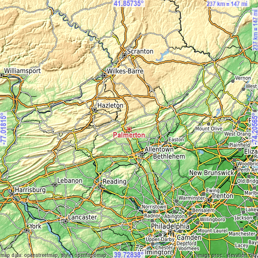
| \ | Map #1 | Map #2 | Topo.Map |
| Scale [m] | 110..480 m | 100..499 m | × |
| Scale [ft] | 361..1575 ft | 328..1637 ft | × |
| Average | 234 m = 768 ft | 227.7 m = 747 ft | × |
| Width | 7.4 km = 4.6 mi | 14.8 km = 9.2 mi | 236.7 km = 147.1 mi |
| Height | 7.4 km = 4.6 mi | 14.8 km = 9.2 mi | 236.7 km = 147.1 mi |
| ↑Max Latitude | 40.834657° | 40.867898° | 41.85735° |
| Latitude at center | 40.8014° | 40.8014° | 40.8014° |
| ↓Min Latitude | 40.768126° | 40.734835° | 39.72838° |
| ← Min Longitude | -75.655845° | -75.699791° | -77.01815° |
| Longitude center | -75.6119° | -75.6119° | -75.6119° |
| →Max Longitude | -75.567955° | -75.524009° | -74.20565° |
Nearby cities:
Cities around Palmerton sort by population:
• Northampton elevation 100 m
16.1 km,  142°
142°
• Lehighton 177 m
9.3 km,  292°
292°
• Jim Thorpe 223 m
13.1 km,  309°
309°
• Slatington 154 m
5.9 km,  179°
179°
• Schnecksville 191 m
14.1 km, 182°
• Egypt 126 m
15.2 km,  152°
152°
• Walnutport 118 m
5.4 km,  168°
168°
• Youngsville 239 m
11.6 km,  101°
101°
• Weissport East 190 m
7.4 km,  302°
302°
• Cherryville 224 m
8.1 km,  130°
130°
• Cementon 99 m
15.2 km, 144°
• Laurys Station 117 m
11.1 km, 141°
Multilingual:
 En español:
Palmerton elevación 126 m.
 En France:
Palmerton élévation 126 m.
 Auf Deutsch:
Palmerton höhe über dem Meeresspiegel ist 126 m.

Sources and notes:
- [note 1] Map square and city borders are not equal. Map elevation data is calculated only from area inside that square.
- [src 1] Elevation data from geonames database provided with same terms of usage.
- [src 2] The elevation map of Palmerton is generated using elevation data from NASA's 3 arcsec (90m) resolution SRTM data.
- [src 3] Base (background) map © OpenStreetMap contributors tiles are generated by Geofabrik and OpenTopoMap.
Copyright & License:
This Palmerton Elevation Map is licensed under CC BY-SA. You may reuse any part from this page, if you give a proper credit by linking to this URL:
 More info on terms of use page.