Effort elevation
Effort (Pennsylvania, Monroe County), United States elevation is 240 meters and Effort elevation in feet is 787 ft above sea level [src 1]. Effort is a populated place (feature code) with elevation that is 39 meters (128 ft) smaller than average city elevation in United States.
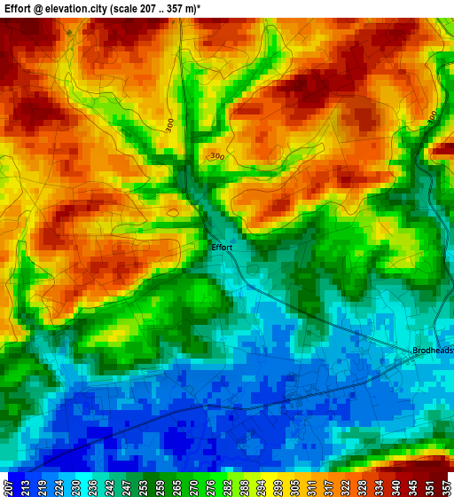
Below is the Elevation map of Effort, which displays elevation range with different colors. Scale of the first map is from 207 to 357 m (679 to 1171 ft) with average elevation of 276.6 meters (=907 ft) [note 1]
These maps also provides idea of topography and contour of this city, they are displayed at different zoom levels. More info about maps, scale and edge coordinates you can find below images.
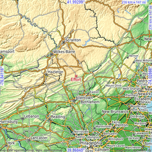
| \ | Map #1 | Topo.Map |
| Scale [m] | 207..357 m | × |
| Scale [ft] | 679..1171 ft | × |
| Average | 276.6 m = 907 ft | × |
| Width | 7.38 km = 4.6 mi | 236.2 km = 146.8 mi |
| Height | 7.38 km = 4.6 mi | 236.2 km = 146.8 mi |
| ↑Max Latitude | 40.972448° | 41.99299° |
| Latitude at center | 40.93926° | 40.93926° |
| ↓Min Latitude | 40.906055° | 39.86845° |
| ← Min Longitude | -75.478855° | -76.84116° |
| Longitude center | -75.43491° | -75.43491° |
| →Max Longitude | -75.390965° | -74.02866° |
Nearby cities:
Cities around Effort sort by population:
• Sierra View elevation 579 m
8.3 km,  345°
345°
• Indian Mountain Lake 548 m
9.4 km,  319°
319°
• Pen Argyl 251 m
17 km,  117°
117°
• Emerald Lakes 615 m
16.6 km,  4°
4°
• Tannersville 274 m
15.6 km,  44°
44°
• Wind Gap 229 m
15.7 km,  130°
130°
• Sun Valley 578 m
8.5 km,  339°
339°
• Sun Valley 363 m
5.4 km,  331°
331°
• Towamensing Trails 502 m
14.7 km,  301°
301°
• Brodheadsville 229 m
3.8 km, 115°
• Youngsville 239 m
17.9 km,  191°
191°
• Saylorsburg 205 m
10.5 km, 117°
Multilingual:
 En español:
Effort elevación 240 m.
 En France:
Effort élévation 240 m.


Sources and notes:
- [note 1] Map square and city borders are not equal. Map elevation data is calculated only from area inside that square.
- [src 1] Elevation data from geonames database provided with same terms of usage.
- [src 2] The elevation map of Effort is generated using elevation data from NASA's 3 arcsec (90m) resolution SRTM data.
- [src 3] Base (background) map © OpenStreetMap contributors tiles are generated by Geofabrik and OpenTopoMap.
Copyright & License:
This Effort Elevation Map is licensed under CC BY-SA. You may reuse any part from this page, if you give a proper credit by linking to this URL:
 More info on terms of use page.