Pen Argyl elevation
Pen Argyl (Pennsylvania, Northampton County), United States elevation is 251 meters and Pen Argyl elevation in feet is 823 ft above sea level [src 1]. Pen Argyl is a populated place (feature code) with elevation that is 28 meters (92 ft) smaller than average city elevation in United States.
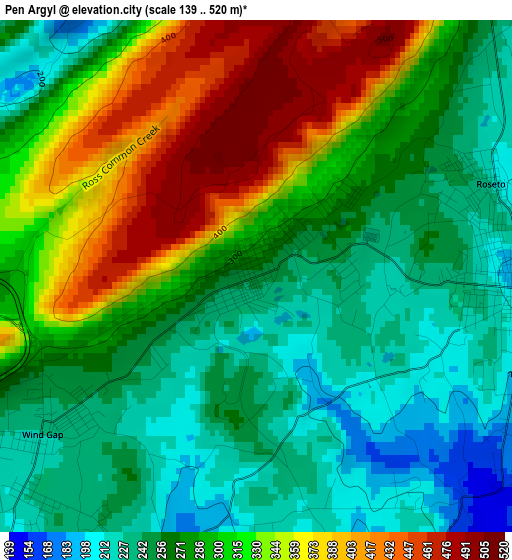
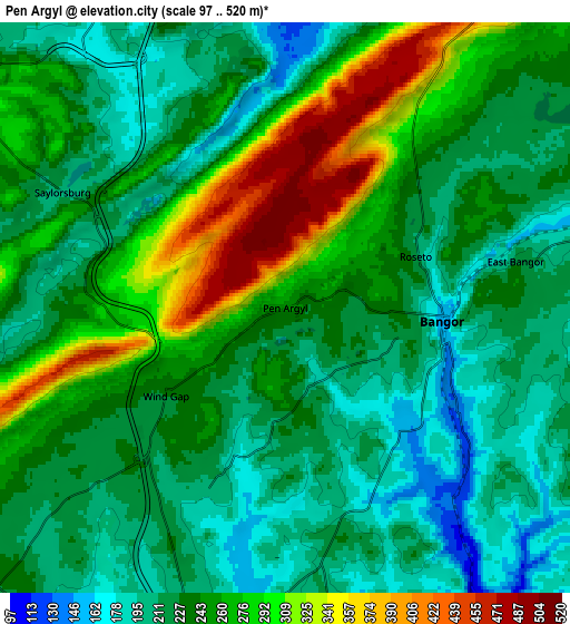
Below is the Elevation map of Pen Argyl, which displays elevation range with different colors. Scale of the first map is from 139 to 520 m (456 to 1706 ft) with average elevation of 292.3 meters (=959 ft) [note 1]
These maps also provides idea of topography and contour of this city, they are displayed at different zoom levels. More info about maps, scale and edge coordinates you can find below images.
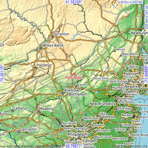
| \ | Map #1 | Map #2 | Topo.Map |
| Scale [m] | 139..520 m | 97..520 m | × |
| Scale [ft] | 456..1706 ft | 318..1706 ft | × |
| Average | 292.3 m = 959 ft | 244.3 m = 802 ft | × |
| Width | 7.39 km = 4.6 mi | 14.78 km = 9.2 mi | 236.5 km = 147 mi |
| Height | 7.39 km = 4.6 mi | 14.78 km = 9.2 mi | 236.5 km = 147 mi |
| ↑Max Latitude | 40.901934° | 40.93514° | 41.92358° |
| Latitude at center | 40.86871° | 40.86871° | 40.86871° |
| ↓Min Latitude | 40.83547° | 40.802213° | 39.79677° |
| ← Min Longitude | -75.298845° | -75.342791° | -76.66115° |
| Longitude center | -75.2549° | -75.2549° | -75.2549° |
| →Max Longitude | -75.210955° | -75.167009° | -73.84865° |
Nearby cities:
Cities around Pen Argyl sort by population:
• Arlington Heights elevation 154 m
13.9 km,  13°
13°
• Stroudsburg 136 m
14.1 km,  21°
21°
• Bangor 156 m
4.1 km,  94°
94°
• Eastlawn Gardens 150 m
13.6 km,  194°
194°
• Wind Gap 229 m
3.8 km,  233°
233°
• Brodheadsville 229 m
13.2 km,  298°
298°
• East Bangor 212 m
6.1 km,  78°
78°
• Roseto 217 m
3.6 km,  68°
68°
• Belfast 164 m
10 km, 191°
• Factoryville 132 m
6.2 km,  142°
142°
• Tatamy 123 m
14.2 km,  180°
180°
• Saylorsburg 205 m
6.5 km, 297°
Multilingual:
 En español:
Pen Argyl elevación 251 m.
 En France:
Pen Argyl élévation 251 m.
 Auf Deutsch:
Pen Argyl höhe über dem Meeresspiegel ist 251 m.

Sources and notes:
- [note 1] Map square and city borders are not equal. Map elevation data is calculated only from area inside that square.
- [src 1] Elevation data from geonames database provided with same terms of usage.
- [src 2] The elevation map of Pen Argyl is generated using elevation data from NASA's 3 arcsec (90m) resolution SRTM data.
- [src 3] Base (background) map © OpenStreetMap contributors tiles are generated by Geofabrik and OpenTopoMap.
Copyright & License:
This Pen Argyl Elevation Map is licensed under CC BY-SA. You may reuse any part from this page, if you give a proper credit by linking to this URL:
 More info on terms of use page.