Sayre elevation
Sayre (Pennsylvania, Bradford County), United States elevation is 238 meters and Sayre elevation in feet is 781 ft above sea level [src 1]. Sayre is a populated place (feature code) with elevation that is 41 meters (135 ft) smaller than average city elevation in United States.
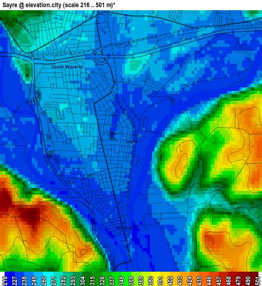
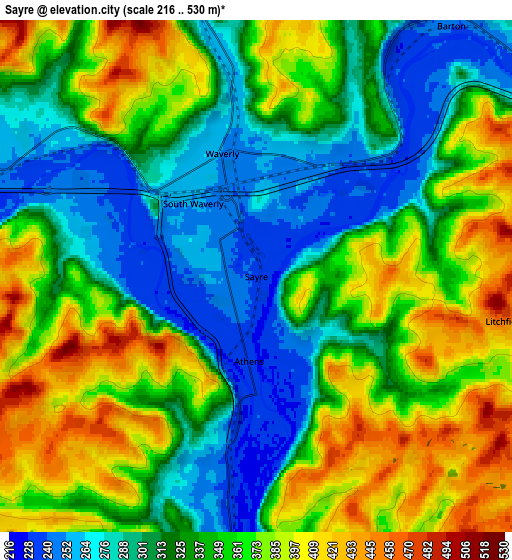
Below is the Elevation map of Sayre, which displays elevation range with different colors. Scale of the first map is from 216 to 501 m (709 to 1644 ft) with average elevation of 284.4 meters (=933 ft) [note 1]
These maps also provides idea of topography and contour of this city, they are displayed at different zoom levels. More info about maps, scale and edge coordinates you can find below images.
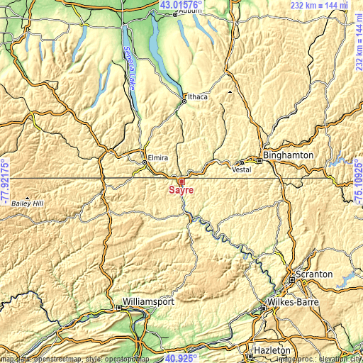
| \ | Map #1 | Map #2 | Topo.Map |
| Scale [m] | 216..501 m | 216..530 m | × |
| Scale [ft] | 709..1644 ft | 709..1739 ft | × |
| Average | 284.4 m = 933 ft | 341.7 m = 1121 ft | × |
| Width | 7.26 km = 4.5 mi | 14.53 km = 9 mi | 232.5 km = 144.5 mi |
| Height | 7.26 km = 4.5 mi | 14.53 km = 9 mi | 232.5 km = 144.5 mi |
| ↑Max Latitude | 42.01162° | 42.044264° | 43.01576° |
| Latitude at center | 41.97896° | 41.97896° | 41.97896° |
| ↓Min Latitude | 41.946283° | 41.913589° | 40.925° |
| ← Min Longitude | -76.559445° | -76.603391° | -77.92175° |
| Longitude center | -76.5155° | -76.5155° | -76.5155° |
| →Max Longitude | -76.471555° | -76.427609° | -75.10925° |
Nearby cities:
Cities around Sayre sort by population:
• Elmira elevation 264 m
27.1 km,  297°
297°
• Southport 271 m
26.5 km,  288°
288°
• Horseheads 274 m
32.7 km,  309°
309°
• West Elmira 273 m
29.4 km, 292°
• Waverly 251 m
3.6 km,  344°
344°
• Elmira Heights 269 m
30.3 km, 303°
• Owego 251 m
25.1 km,  56°
56°
• Athens 233 m
2.4 km,  184°
184°
• Towanda 223 m
24.3 km,  165°
165°
• Troy 338 m
31.1 km,  226°
226°
• Apalachin 259 m
31.5 km,  71°
71°
• South Waverly 252 m
2.7 km,  319°
319°
Multilingual:
 En español:
Sayre elevación 238 m.
 En France:
Sayre élévation 238 m.


Sources and notes:
- [note 1] Map square and city borders are not equal. Map elevation data is calculated only from area inside that square.
- [src 1] Elevation data from geonames database provided with same terms of usage.
- [src 2] The elevation map of Sayre is generated using elevation data from NASA's 3 arcsec (90m) resolution SRTM data.
- [src 3] Base (background) map © OpenStreetMap contributors tiles are generated by Geofabrik and OpenTopoMap.
Copyright & License:
This Sayre Elevation Map is licensed under CC BY-SA. You may reuse any part from this page, if you give a proper credit by linking to this URL:
 More info on terms of use page.