Southport elevation
Southport (New York, Chemung County), United States elevation is 271 meters and Southport elevation in feet is 889 ft above sea level [src 1]. Southport is a populated place (feature code) with elevation that is 8 meters (26 ft) smaller than average city elevation in United States.
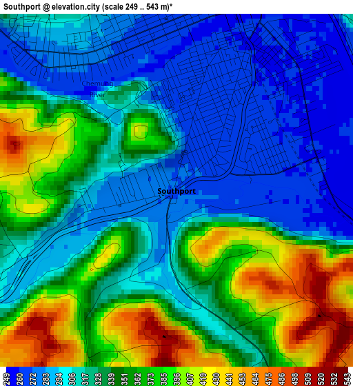
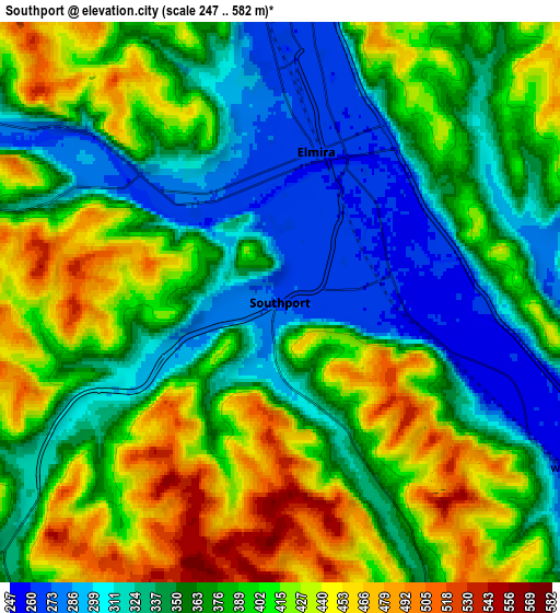
Below is the Elevation map of Southport, which displays elevation range with different colors. Scale of the first map is from 249 to 543 m (817 to 1781 ft) with average elevation of 334.1 meters (=1096 ft) [note 1]
These maps also provides idea of topography and contour of this city, they are displayed at different zoom levels. More info about maps, scale and edge coordinates you can find below images.
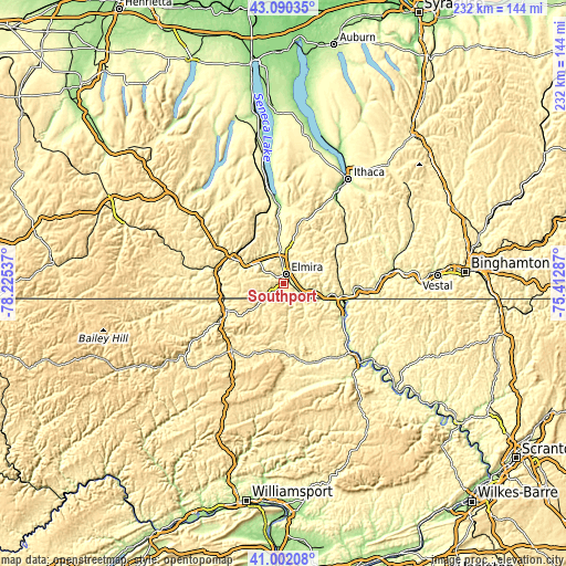
| \ | Map #1 | Map #2 | Topo.Map |
| Scale [m] | 249..543 m | 247..582 m | × |
| Scale [ft] | 817..1781 ft | 810..1909 ft | × |
| Average | 334.1 m = 1096 ft | 377.8 m = 1240 ft | × |
| Width | 7.26 km = 4.5 mi | 14.51 km = 9 mi | 232.2 km = 144.3 mi |
| Height | 7.26 km = 4.5 mi | 14.51 km = 9 mi | 232.2 km = 144.3 mi |
| ↑Max Latitude | 42.087421° | 42.120026° | 43.09035° |
| Latitude at center | 42.0548° | 42.0548° | 42.0548° |
| ↓Min Latitude | 42.022162° | 41.989507° | 41.00208° |
| ← Min Longitude | -76.863065° | -76.907011° | -78.22537° |
| Longitude center | -76.81912° | -76.81912° | -76.81912° |
| →Max Longitude | -76.775175° | -76.731229° | -75.41287° |
Nearby cities:
Cities around Southport sort by population:
• Elmira elevation 264 m
4 km,  13°
13°
• Corning 289 m
21.8 km,  296°
296°
• Horseheads 274 m
12.5 km,  359°
359°
• Big Flats 277 m
13.4 km,  313°
313°
• West Elmira 273 m
3.4 km,  320°
320°
• Waverly 251 m
24.6 km,  101°
101°
• Gang Mills 290 m
26.2 km,  292°
292°
• Elmira Heights 269 m
8.3 km, 359°
• Horseheads North 291 m
15.4 km,  3°
3°
• Painted Post 291 m
25.6 km, 297°
• South Corning 293 m
19.5 km, 292°
• South Waverly 252 m
24.1 km,  105°
105°
Multilingual:
 En español:
Southport elevación 271 m.
 En France:
Southport élévation 271 m.
 Auf Deutsch:
Southport höhe über dem Meeresspiegel ist 271 m.

Sources and notes:
- [note 1] Map square and city borders are not equal. Map elevation data is calculated only from area inside that square.
- [src 1] Elevation data from geonames database provided with same terms of usage.
- [src 2] The elevation map of Southport is generated using elevation data from NASA's 3 arcsec (90m) resolution SRTM data.
- [src 3] Base (background) map © OpenStreetMap contributors tiles are generated by Geofabrik and OpenTopoMap.
Copyright & License:
This Southport Elevation Map is licensed under CC BY-SA. You may reuse any part from this page, if you give a proper credit by linking to this URL:
 More info on terms of use page.