Rothsville elevation
Rothsville (Pennsylvania, Lancaster County), United States elevation is 154 meters and Rothsville elevation in feet is 505 ft above sea level [src 1]. Rothsville is a populated place (feature code) with elevation that is 125 meters (410 ft) smaller than average city elevation in United States.
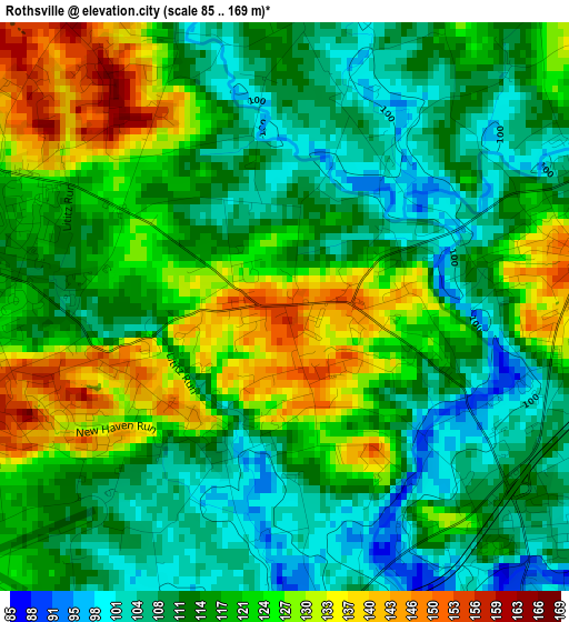
Below is the Elevation map of Rothsville, which displays elevation range with different colors. Scale of the first map is from 85 to 169 m (279 to 554 ft) with average elevation of 117.5 meters (=385 ft) [note 1]
These maps also provides idea of topography and contour of this city, they are displayed at different zoom levels. More info about maps, scale and edge coordinates you can find below images.
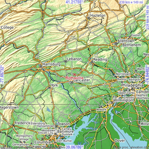
| \ | Map #1 | Topo.Map |
| Scale [m] | 85..169 m | × |
| Scale [ft] | 279..554 ft | × |
| Average | 117.5 m = 385 ft | × |
| Width | 7.47 km = 4.6 mi | 239 km = 148.5 mi |
| Height | 7.47 km = 4.6 mi | 239 km = 148.5 mi |
| ↑Max Latitude | 40.184791° | 41.21755° |
| Latitude at center | 40.15121° | 40.15121° |
| ↓Min Latitude | 40.117612° | 39.06786° |
| ← Min Longitude | -76.295015° | -77.65732° |
| Longitude center | -76.25107° | -76.25107° |
| →Max Longitude | -76.207125° | -74.84482° |
Nearby cities:
Cities around Rothsville sort by population:
• Ephrata elevation 113 m
6.9 km,  62°
62°
• Lititz 119 m
4.8 km,  278°
278°
• Leola 133 m
9 km,  141°
141°
• Manheim 128 m
12.3 km, 276°
• East Petersburg 114 m
10.4 km,  237°
237°
• Akron 160 m
4.2 km,  81°
81°
• Reamstown 120 m
12.8 km, 58°
• Brownstown 103 m
4.4 km,  134°
134°
• Clay 109 m
7.5 km,  357°
357°
• Brickerville 164 m
9.4 km,  332°
332°
• Schoeneck 174 m
12 km,  33°
33°
• Penryn 177 m
11.6 km,  301°
301°
Multilingual:
 En español:
Rothsville elevación 154 m.
 En France:
Rothsville élévation 154 m.
 Auf Deutsch:
Rothsville höhe über dem Meeresspiegel ist 154 m.

Sources and notes:
- [note 1] Map square and city borders are not equal. Map elevation data is calculated only from area inside that square.
- [src 1] Elevation data from geonames database provided with same terms of usage.
- [src 2] The elevation map of Rothsville is generated using elevation data from NASA's 3 arcsec (90m) resolution SRTM data.
- [src 3] Base (background) map © OpenStreetMap contributors tiles are generated by Geofabrik and OpenTopoMap.
Copyright & License:
This Rothsville Elevation Map is licensed under CC BY-SA. You may reuse any part from this page, if you give a proper credit by linking to this URL:
 More info on terms of use page.