Manheim elevation
Manheim (Pennsylvania, Lancaster County), United States elevation is 128 meters and Manheim elevation in feet is 420 ft above sea level [src 1]. Manheim is a populated place (feature code) with elevation that is 151 meters (495 ft) smaller than average city elevation in United States.
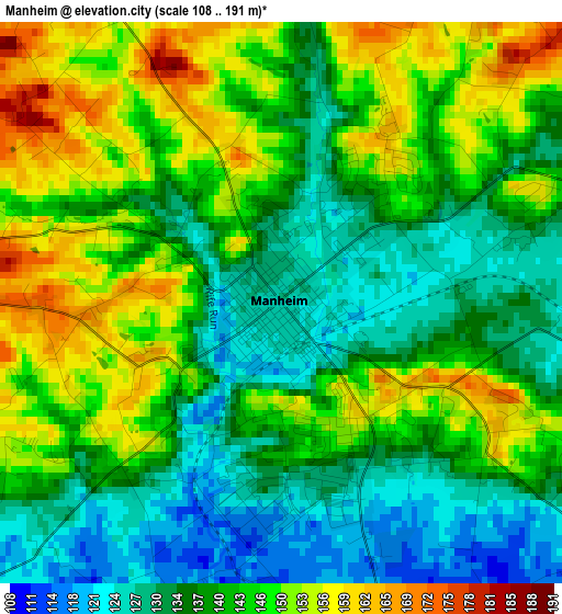
Below is the Elevation map of Manheim, which displays elevation range with different colors. Scale of the first map is from 108 to 191 m (354 to 627 ft) with average elevation of 140.9 meters (=462 ft) [note 1]
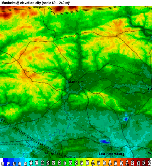
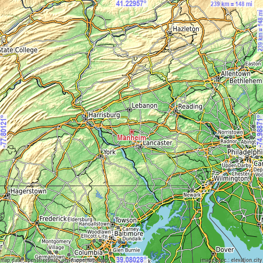
These maps also provides idea of topography and contour of this city, they are displayed at different zoom levels. More info about maps, scale and edge coordinates you can find below images.
| \ | Map #1 | Map #2 | Topo.Map |
| Scale [m] | 108..191 m | 69..240 m | × |
| Scale [ft] | 354..627 ft | 226..787 ft | × |
| Average | 140.9 m = 462 ft | 140.7 m = 462 ft | × |
| Width | 7.47 km = 4.6 mi | 14.94 km = 9.3 mi | 239 km = 148.5 mi |
| Height | 7.47 km = 4.6 mi | 14.94 km = 9.3 mi | 239 km = 148.5 mi |
| ↑Max Latitude | 40.197005° | 40.230563° | 41.22957° |
| Latitude at center | 40.16343° | 40.16343° | 40.16343° |
| ↓Min Latitude | 40.129838° | 40.09623° | 39.08028° |
| ← Min Longitude | -76.438905° | -76.482851° | -77.80121° |
| Longitude center | -76.39496° | -76.39496° | -76.39496° |
| →Max Longitude | -76.351015° | -76.307069° | -74.98871° |
Nearby cities:
Cities around Manheim sort by population:
• Lititz elevation 119 m
7.5 km,  95°
95°
• Mount Joy 116 m
11 km,  237°
237°
• East Petersburg 114 m
7.9 km,  153°
153°
• Cornwall 194 m
12.3 km,  355°
355°
• Rothsville 154 m
12.3 km, 96°
• Mountville 138 m
14.1 km,  192°
192°
• Salunga 126 m
7.4 km,  199°
199°
• Landisville 124 m
7.7 km, 189°
• Rheems 130 m
15.4 km,  256°
256°
• Clay 109 m
13.3 km,  62°
62°
• Brickerville 164 m
10.5 km,  48°
48°
• Penryn 177 m
5.2 km,  26°
26°
Multilingual:
 En español:
Manheim elevación 128 m.
 En France:
Manheim élévation 128 m.


Sources and notes:
- [note 1] Map square and city borders are not equal. Map elevation data is calculated only from area inside that square.
- [src 1] Elevation data from geonames database provided with same terms of usage.
- [src 2] The elevation map of Manheim is generated using elevation data from NASA's 3 arcsec (90m) resolution SRTM data.
- [src 3] Base (background) map © OpenStreetMap contributors tiles are generated by Geofabrik and OpenTopoMap.
Copyright & License:
This Manheim Elevation Map is licensed under CC BY-SA. You may reuse any part from this page, if you give a proper credit by linking to this URL:
 More info on terms of use page.