Oakdale elevation
Oakdale (Pennsylvania, Allegheny County), United States elevation is 274 meters and Oakdale elevation in feet is 899 ft above sea level [src 1]. Oakdale is a populated place (feature code) with elevation that is 5 meters (16 ft) smaller than average city elevation in United States.
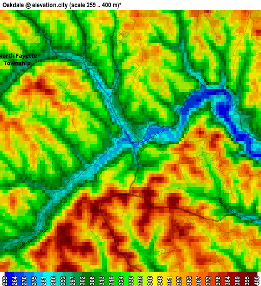
Below is the Elevation map of Oakdale, which displays elevation range with different colors. Scale of the first map is from 259 to 400 m (850 to 1312 ft) with average elevation of 334.1 meters (=1096 ft) [note 1]
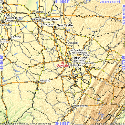
These maps also provides idea of topography and contour of this city, they are displayed at different zoom levels. More info about maps, scale and edge coordinates you can find below images.
| \ | Map #1 | Topo.Map |
| Scale [m] | 259..400 m | × |
| Scale [ft] | 850..1312 ft | × |
| Average | 334.1 m = 1096 ft | × |
| Width | 7.44 km = 4.6 mi | 238.2 km = 148 mi |
| Height | 7.44 km = 4.6 mi | 238.1 km = 147.9 mi |
| ↑Max Latitude | 40.431579° | 41.46053° |
| Latitude at center | 40.39812° | 40.39812° |
| ↓Min Latitude | 40.364645° | 39.31868° |
| ← Min Longitude | -80.229555° | -81.59186° |
| Longitude center | -80.18561° | -80.18561° |
| →Max Longitude | -80.141665° | -78.77936° |
Nearby cities:
Cities around Oakdale sort by population:
• Upper Saint Clair elevation 332 m
11.1 km,  128°
128°
• Carnegie 239 m
8.7 km,  82°
82°
• Crafton 268 m
10.9 km,  67°
67°
• Bridgeville 263 m
7.9 km, 126°
• Ingram 283 m
11.3 km,  61°
61°
• Imperial 306 m
7.6 km,  318°
318°
• Cecil-Bishop 347 m
8.9 km,  184°
184°
• McDonald 301 m
5.1 km,  233°
233°
• Sturgeon 291 m
2.6 km,  235°
235°
• Heidelberg 249 m
8 km,  94°
94°
• Rennerdale 297 m
3.7 km, 89°
• Enlow 292 m
7.4 km,  327°
327°
Multilingual:
 En español:
Oakdale elevación 274 m.
 En France:
Oakdale élévation 274 m.


Sources and notes:
- [note 1] Map square and city borders are not equal. Map elevation data is calculated only from area inside that square.
- [src 1] Elevation data from geonames database provided with same terms of usage.
- [src 2] The elevation map of Oakdale is generated using elevation data from NASA's 3 arcsec (90m) resolution SRTM data.
- [src 3] Base (background) map © OpenStreetMap contributors tiles are generated by Geofabrik and OpenTopoMap.
Copyright & License:
This Oakdale Elevation Map is licensed under CC BY-SA. You may reuse any part from this page, if you give a proper credit by linking to this URL:
 More info on terms of use page.