Ingram elevation
Ingram (Pennsylvania, Allegheny County), United States elevation is 283 meters and Ingram elevation in feet is 928 ft above sea level [src 1]. Ingram is a populated place (feature code) with elevation that is 4 meters (13 ft) bigger than average city elevation in United States.
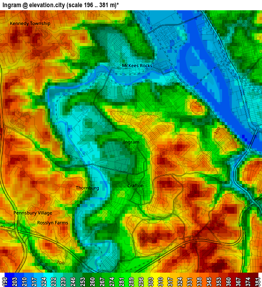
Below is the Elevation map of Ingram, which displays elevation range with different colors. Scale of the first map is from 196 to 381 m (643 to 1250 ft) with average elevation of 286.3 meters (=939 ft) [note 1]
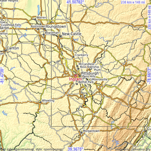
These maps also provides idea of topography and contour of this city, they are displayed at different zoom levels. More info about maps, scale and edge coordinates you can find below images.
| \ | Map #1 | Topo.Map |
| Scale [m] | 196..381 m | × |
| Scale [ft] | 643..1250 ft | × |
| Average | 286.3 m = 939 ft | × |
| Width | 7.44 km = 4.6 mi | 238 km = 147.9 mi |
| Height | 7.44 km = 4.6 mi | 238 km = 147.9 mi |
| ↑Max Latitude | 40.479615° | 41.50782° |
| Latitude at center | 40.44618° | 40.44618° |
| ↓Min Latitude | 40.412729° | 39.3675° |
| ← Min Longitude | -80.111495° | -81.4738° |
| Longitude center | -80.06755° | -80.06755° |
| →Max Longitude | -80.023605° | -78.6613° |
Nearby cities:
Cities around Ingram sort by population:
• Pittsburgh elevation 239 m
6.1 km,  95°
95°
• Dormont 362 m
6.3 km,  152°
152°
• Bellevue 297 m
5.5 km,  14°
14°
• Carnegie 239 m
4.4 km,  197°
197°
• McKees Rocks 225 m
2.2 km,  4°
4°
• Crafton 268 m
1.2 km,  174°
174°
• Green Tree 365 m
4.3 km, 154°
• Avalon 287 m
6.1 km,  359°
359°
• Mount Oliver 351 m
7.6 km,  117°
117°
• Emsworth 218 m
7.5 km,  342°
342°
• Ben Avon 258 m
7 km,  349°
349°
• Heidelberg 249 m
6.3 km, 198°
Multilingual:
 En español:
Ingram elevación 283 m.
 En France:
Ingram élévation 283 m.


Sources and notes:
- [note 1] Map square and city borders are not equal. Map elevation data is calculated only from area inside that square.
- [src 1] Elevation data from geonames database provided with same terms of usage.
- [src 2] The elevation map of Ingram is generated using elevation data from NASA's 3 arcsec (90m) resolution SRTM data.
- [src 3] Base (background) map © OpenStreetMap contributors tiles are generated by Geofabrik and OpenTopoMap.
Copyright & License:
This Ingram Elevation Map is licensed under CC BY-SA. You may reuse any part from this page, if you give a proper credit by linking to this URL:
 More info on terms of use page.