Green Tree elevation
Green Tree (Pennsylvania, Allegheny County), United States elevation is 365 meters and Green Tree elevation in feet is 1198 ft above sea level [src 1]. Green Tree is a populated place (feature code) with elevation that is 86 meters (282 ft) bigger than average city elevation in United States.
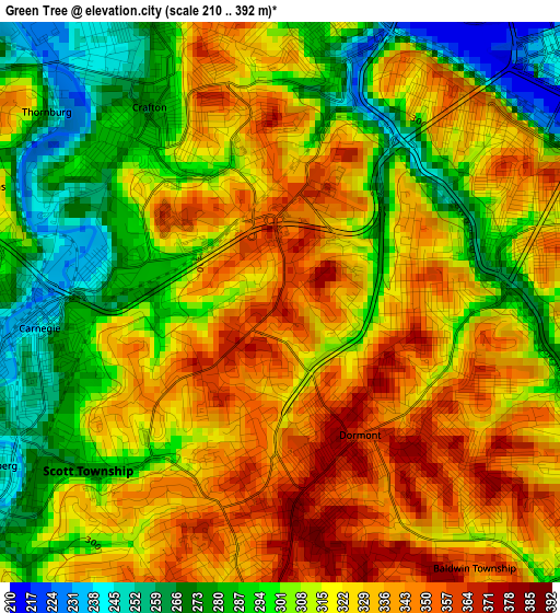
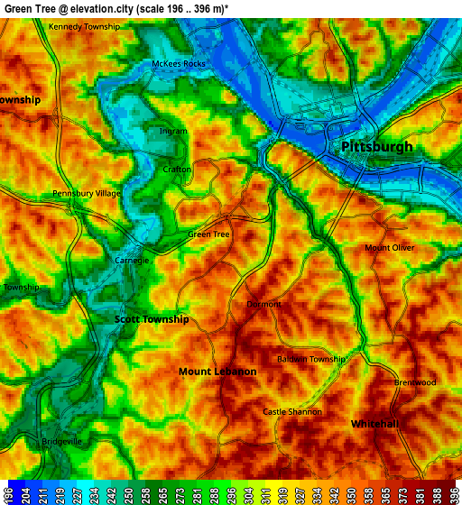
Below is the Elevation map of Green Tree, which displays elevation range with different colors. Scale of the first map is from 210 to 392 m (689 to 1286 ft) with average elevation of 314.2 meters (=1031 ft) [note 1]
These maps also provides idea of topography and contour of this city, they are displayed at different zoom levels. More info about maps, scale and edge coordinates you can find below images.
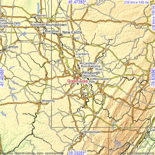
| \ | Map #1 | Map #2 | Topo.Map |
| Scale [m] | 210..392 m | 196..396 m | × |
| Scale [ft] | 689..1286 ft | 643..1299 ft | × |
| Average | 314.2 m = 1031 ft | 309.1 m = 1014 ft | × |
| Width | 7.44 km = 4.6 mi | 14.88 km = 9.2 mi | 238.1 km = 147.9 mi |
| Height | 7.44 km = 4.6 mi | 14.88 km = 9.2 mi | 238.1 km = 147.9 mi |
| ↑Max Latitude | 40.445192° | 40.478627° | 41.47393° |
| Latitude at center | 40.41174° | 40.41174° | 40.41174° |
| ↓Min Latitude | 40.378271° | 40.344786° | 39.33251° |
| ← Min Longitude | -80.089555° | -80.133501° | -81.45186° |
| Longitude center | -80.04561° | -80.04561° | -80.04561° |
| →Max Longitude | -80.001665° | -79.957719° | -78.63936° |
Nearby cities:
Cities around Green Tree sort by population:
• Pittsburgh elevation 239 m
5.3 km,  52°
52°
• Mount Lebanon 323 m
6.3 km,  183°
183°
• Whitehall 387 m
7.3 km,  140°
140°
• Brentwood 372 m
7.5 km,  127°
127°
• Dormont 362 m
2.1 km,  148°
148°
• Castle Shannon 317 m
5.6 km,  159°
159°
• Carnegie 239 m
3.2 km,  263°
263°
• McKees Rocks 225 m
6.2 km,  344°
344°
• Crafton 268 m
3.1 km,  326°
326°
• Mount Oliver 351 m
4.9 km,  86°
86°
• Ingram 283 m
4.3 km, 334°
• Heidelberg 249 m
4.4 km,  240°
240°
Multilingual:
 En español:
Green Tree elevación 365 m.
 En France:
Green Tree élévation 365 m.
 Auf Deutsch:
Green Tree höhe über dem Meeresspiegel ist 365 m.

Sources and notes:
- [note 1] Map square and city borders are not equal. Map elevation data is calculated only from area inside that square.
- [src 1] Elevation data from geonames database provided with same terms of usage.
- [src 2] The elevation map of Green Tree is generated using elevation data from NASA's 3 arcsec (90m) resolution SRTM data.
- [src 3] Base (background) map © OpenStreetMap contributors tiles are generated by Geofabrik and OpenTopoMap.
Copyright & License:
This Green Tree Elevation Map is licensed under CC BY-SA. You may reuse any part from this page, if you give a proper credit by linking to this URL:
 More info on terms of use page.