Emsworth elevation
Emsworth (Pennsylvania, Allegheny County), United States elevation is 218 meters and Emsworth elevation in feet is 715 ft above sea level [src 1]. Emsworth is a populated place (feature code) with elevation that is 61 meters (200 ft) smaller than average city elevation in United States.
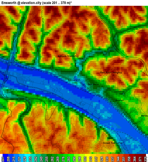
Below is the Elevation map of Emsworth, which displays elevation range with different colors. Scale of the first map is from 201 to 378 m (659 to 1240 ft) with average elevation of 294.4 meters (=966 ft) [note 1]
These maps also provides idea of topography and contour of this city, they are displayed at different zoom levels. More info about maps, scale and edge coordinates you can find below images.
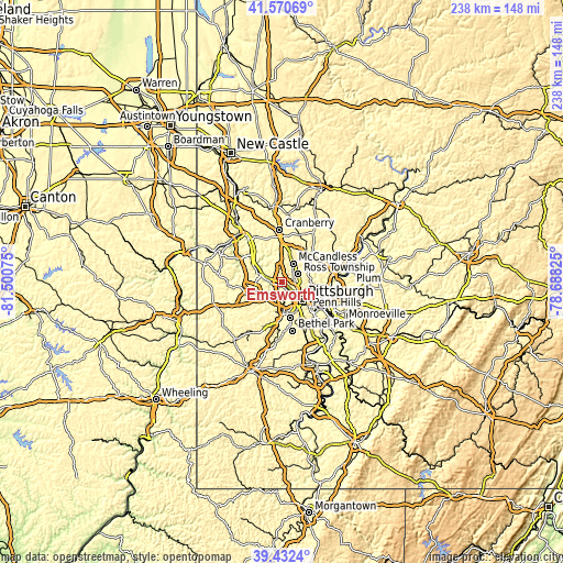
| \ | Map #1 | Topo.Map |
| Scale [m] | 201..378 m | × |
| Scale [ft] | 659..1240 ft | × |
| Average | 294.4 m = 966 ft | × |
| Width | 7.43 km = 4.6 mi | 237.8 km = 147.8 mi |
| Height | 7.43 km = 4.6 mi | 237.7 km = 147.7 mi |
| ↑Max Latitude | 40.543473° | 41.57069° |
| Latitude at center | 40.51007° | 40.51007° |
| ↓Min Latitude | 40.47665° | 39.4324° |
| ← Min Longitude | -80.138445° | -81.50075° |
| Longitude center | -80.0945° | -80.0945° |
| →Max Longitude | -80.050555° | -78.68825° |
Nearby cities:
Cities around Emsworth sort by population:
• Franklin Park elevation 376 m
8.2 km,  3°
3°
• Bellevue 297 m
4 km,  116°
116°
• West View 349 m
5.3 km,  75°
75°
• McKees Rocks 225 m
5.5 km,  153°
153°
• Crafton 268 m
8.7 km,  163°
163°
• Coraopolis 220 m
6.2 km,  278°
278°
• Avalon 287 m
2.5 km,  114°
114°
• Sewickley 228 m
8.2 km,  291°
291°
• Millvale 244 m
10.4 km, 108°
• Ingram 283 m
7.5 km, 162°
• Ben Avon 258 m
1 km,  102°
102°
• Edgeworth 221 m
9.5 km,  298°
298°
Multilingual:
 En español:
Emsworth elevación 218 m.
 En France:
Emsworth élévation 218 m.
 Auf Deutsch:
Emsworth höhe über dem Meeresspiegel ist 218 m.

Sources and notes:
- [note 1] Map square and city borders are not equal. Map elevation data is calculated only from area inside that square.
- [src 1] Elevation data from geonames database provided with same terms of usage.
- [src 2] The elevation map of Emsworth is generated using elevation data from NASA's 3 arcsec (90m) resolution SRTM data.
- [src 3] Base (background) map © OpenStreetMap contributors tiles are generated by Geofabrik and OpenTopoMap.
Copyright & License:
This Emsworth Elevation Map is licensed under CC BY-SA. You may reuse any part from this page, if you give a proper credit by linking to this URL:
 More info on terms of use page.