Imperial elevation
Imperial (Pennsylvania, Allegheny County), United States elevation is 306 meters and Imperial elevation in feet is 1004 ft above sea level [src 1]. Imperial is a populated place (feature code) with elevation that is 27 meters (89 ft) bigger than average city elevation in United States.
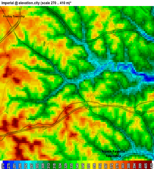
Below is the Elevation map of Imperial, which displays elevation range with different colors. Scale of the first map is from 270 to 410 m (886 to 1345 ft) with average elevation of 340.9 meters (=1118 ft) [note 1]
These maps also provides idea of topography and contour of this city, they are displayed at different zoom levels. More info about maps, scale and edge coordinates you can find below images.
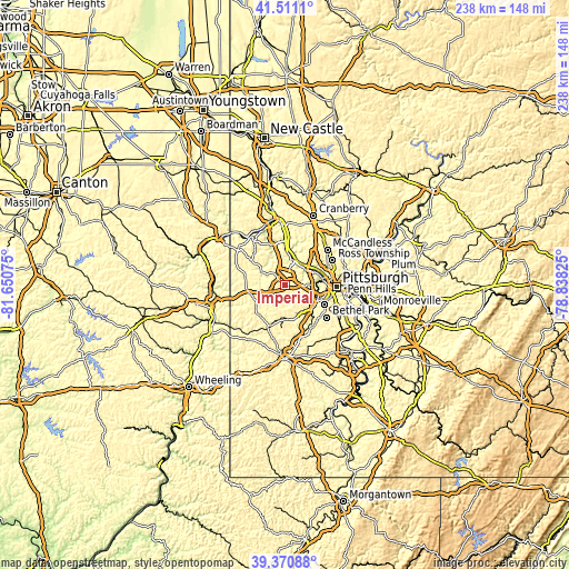
| \ | Map #1 | Topo.Map |
| Scale [m] | 270..410 m | × |
| Scale [ft] | 886..1345 ft | × |
| Average | 340.9 m = 1118 ft | × |
| Width | 7.44 km = 4.6 mi | 238 km = 147.9 mi |
| Height | 7.44 km = 4.6 mi | 238 km = 147.9 mi |
| ↑Max Latitude | 40.482943° | 41.5111° |
| Latitude at center | 40.44951° | 40.44951° |
| ↓Min Latitude | 40.41606° | 39.37088° |
| ← Min Longitude | -80.288445° | -81.65075° |
| Longitude center | -80.2445° | -80.2445° |
| →Max Longitude | -80.200555° | -78.83825° |
Nearby cities:
Cities around Imperial sort by population:
• Carnot-Moon elevation 346 m
8 km,  16°
16°
• Carnegie 239 m
14.4 km,  108°
108°
• Coraopolis 220 m
10.1 km,  40°
40°
• Sewickley 228 m
10.9 km,  27°
27°
• Emsworth 218 m
14.4 km,  62°
62°
• McDonald 301 m
8.8 km,  174°
174°
• Sturgeon 291 m
7.7 km,  158°
158°
• Edgeworth 221 m
12.1 km, 21°
• Oakdale 274 m
7.6 km,  138°
138°
• Leetsdale 217 m
13 km,  13°
13°
• Rennerdale 297 m
10.4 km,  123°
123°
• Enlow 292 m
1.1 km, 61°
Multilingual:
 En español:
Imperial elevación 306 m.
 En France:
Imperial élévation 306 m.
 Auf Deutsch:
Imperial höhe über dem Meeresspiegel ist 306 m.

Sources and notes:
- [note 1] Map square and city borders are not equal. Map elevation data is calculated only from area inside that square.
- [src 1] Elevation data from geonames database provided with same terms of usage.
- [src 2] The elevation map of Imperial is generated using elevation data from NASA's 3 arcsec (90m) resolution SRTM data.
- [src 3] Base (background) map © OpenStreetMap contributors tiles are generated by Geofabrik and OpenTopoMap.
Copyright & License:
This Imperial Elevation Map is licensed under CC BY-SA. You may reuse any part from this page, if you give a proper credit by linking to this URL:
 More info on terms of use page.