Northumberland elevation
Northumberland (Pennsylvania, Northumberland County), United States elevation is 152 meters and Northumberland elevation in feet is 499 ft above sea level [src 1]. Northumberland is a populated place (feature code) with elevation that is 127 meters (417 ft) smaller than average city elevation in United States.
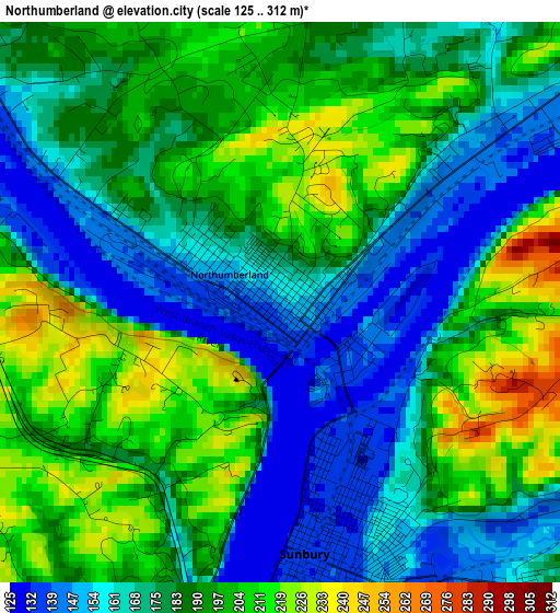
Below is the Elevation map of Northumberland, which displays elevation range with different colors. Scale of the first map is from 125 to 312 m (410 to 1024 ft) with average elevation of 183.1 meters (=601 ft) [note 1]
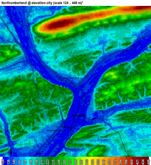
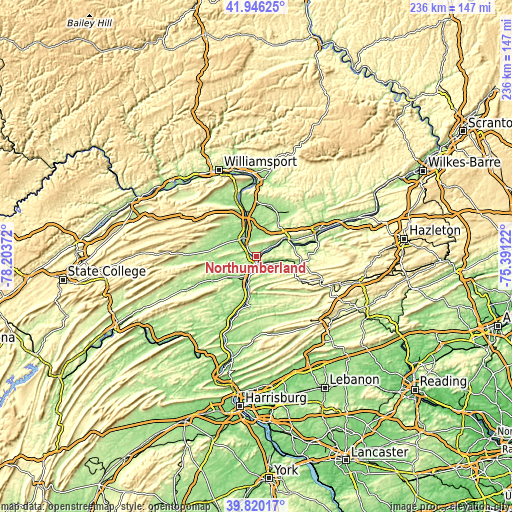
These maps also provides idea of topography and contour of this city, they are displayed at different zoom levels. More info about maps, scale and edge coordinates you can find below images.
| \ | Map #1 | Map #2 | Topo.Map |
| Scale [m] | 125..312 m | 124..446 m | × |
| Scale [ft] | 410..1024 ft | 407..1463 ft | × |
| Average | 183.1 m = 601 ft | 198.9 m = 653 ft | × |
| Width | 7.39 km = 4.6 mi | 14.78 km = 9.2 mi | 236.4 km = 146.9 mi |
| Height | 7.39 km = 4.6 mi | 14.77 km = 9.2 mi | 236.4 km = 146.9 mi |
| ↑Max Latitude | 40.924962° | 40.958157° | 41.94625° |
| Latitude at center | 40.89175° | 40.89175° | 40.89175° |
| ↓Min Latitude | 40.858521° | 40.825276° | 39.82017° |
| ← Min Longitude | -76.841415° | -76.885361° | -78.20372° |
| Longitude center | -76.79747° | -76.79747° | -76.79747° |
| →Max Longitude | -76.753525° | -76.709579° | -75.39122° |
Nearby cities:
Cities around Northumberland sort by population:
• Sunbury elevation 138 m
3.3 km,  175°
175°
• Milton 153 m
14 km,  342°
342°
• Selinsgrove 139 m
11.7 km,  207°
207°
• Lewisburg 148 m
10.9 km,  317°
317°
• Danville 146 m
17.4 km,  62°
62°
• Mechanicsville 181 m
19.6 km, 64°
• Riverside 158 m
15.8 km, 63°
• Trevorton 260 m
16.1 km,  139°
139°
• Shamokin Dam 145 m
5.1 km,  201°
201°
• Linntown 143 m
11.3 km,  311°
311°
• Hummels Wharf 138 m
7.4 km, 205°
• New Columbia 145 m
17.6 km, 340°
Multilingual:
 En español:
Northumberland elevación 152 m.
 En France:
Northumberland élévation 152 m.
 Auf Deutsch:
Northumberland höhe über dem Meeresspiegel ist 152 m.

Sources and notes:
- [note 1] Map square and city borders are not equal. Map elevation data is calculated only from area inside that square.
- [src 1] Elevation data from geonames database provided with same terms of usage.
- [src 2] The elevation map of Northumberland is generated using elevation data from NASA's 3 arcsec (90m) resolution SRTM data.
- [src 3] Base (background) map © OpenStreetMap contributors tiles are generated by Geofabrik and OpenTopoMap.
Copyright & License:
This Northumberland Elevation Map is licensed under CC BY-SA. You may reuse any part from this page, if you give a proper credit by linking to this URL:
 More info on terms of use page.