Lewisburg elevation
Lewisburg (Pennsylvania, Union County), United States elevation is 148 meters and Lewisburg elevation in feet is 486 ft above sea level [src 1]. Lewisburg is a seat of a second-order administrative division (feature code) with elevation that is 131 meters (430 ft) smaller than average city elevation in United States.
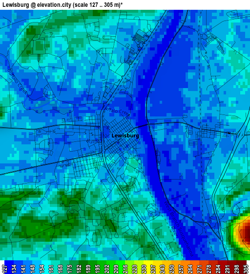
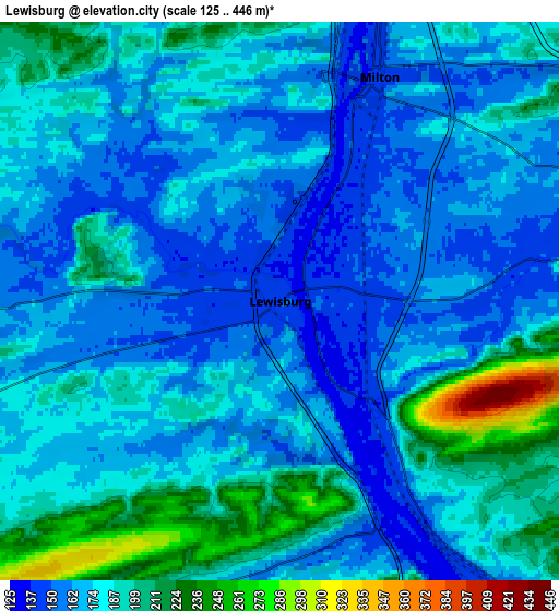
Below is the Elevation map of Lewisburg, which displays elevation range with different colors. Scale of the first map is from 127 to 305 m (417 to 1001 ft) with average elevation of 153.4 meters (=503 ft) [note 1]
These maps also provides idea of topography and contour of this city, they are displayed at different zoom levels. More info about maps, scale and edge coordinates you can find below images.
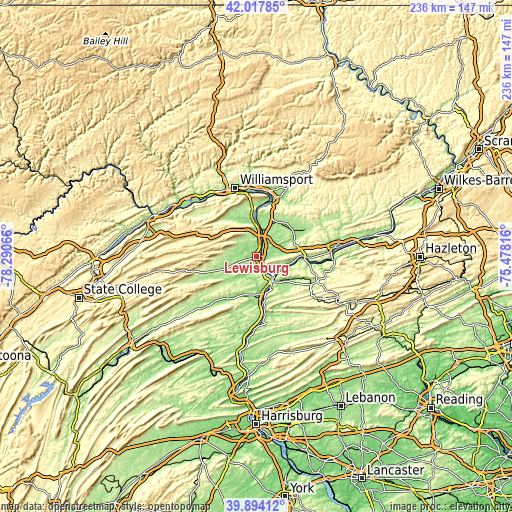
| \ | Map #1 | Map #2 | Topo.Map |
| Scale [m] | 127..305 m | 125..446 m | × |
| Scale [ft] | 417..1001 ft | 410..1463 ft | × |
| Average | 153.4 m = 503 ft | 177.6 m = 583 ft | × |
| Width | 7.38 km = 4.6 mi | 14.76 km = 9.2 mi | 236.1 km = 146.7 mi |
| Height | 7.38 km = 4.6 mi | 14.76 km = 9.2 mi | 236.1 km = 146.7 mi |
| ↑Max Latitude | 40.997705° | 41.030864° | 42.01785° |
| Latitude at center | 40.96453° | 40.96453° | 40.96453° |
| ↓Min Latitude | 40.931338° | 40.898129° | 39.89412° |
| ← Min Longitude | -76.928355° | -76.972301° | -78.29066° |
| Longitude center | -76.88441° | -76.88441° | -76.88441° |
| →Max Longitude | -76.840465° | -76.796519° | -75.47816° |
Nearby cities:
Cities around Lewisburg sort by population:
• Sunbury elevation 138 m
13.6 km,  146°
146°
• Milton 153 m
6.1 km,  30°
30°
• Selinsgrove 139 m
18.5 km,  174°
174°
• Northumberland 152 m
10.9 km,  137°
137°
• Mifflinburg 181 m
14.7 km,  249°
249°
• Watsontown 149 m
13.5 km,  7°
7°
• Riverside 158 m
21.5 km,  92°
92°
• Shamokin Dam 145 m
14 km,  157°
157°
• Linntown 143 m
1.4 km,  243°
243°
• Dewart 148 m
16.1 km,  2°
2°
• Hummels Wharf 138 m
15.3 km, 164°
• New Columbia 145 m
8.6 km, 9°
Multilingual:
 En español:
Lewisburg elevación 148 m.
 En France:
Lewisburg élévation 148 m.
 Auf Deutsch:
Lewisburg höhe über dem Meeresspiegel ist 148 m.

Sources and notes:
- [note 1] Map square and city borders are not equal. Map elevation data is calculated only from area inside that square.
- [src 1] Elevation data from geonames database provided with same terms of usage.
- [src 2] The elevation map of Lewisburg is generated using elevation data from NASA's 3 arcsec (90m) resolution SRTM data.
- [src 3] Base (background) map © OpenStreetMap contributors tiles are generated by Geofabrik and OpenTopoMap.
Copyright & License:
This Lewisburg Elevation Map is licensed under CC BY-SA. You may reuse any part from this page, if you give a proper credit by linking to this URL:
 More info on terms of use page.