Milroy elevation
Milroy (Pennsylvania, Mifflin County), United States elevation is 238 meters and Milroy elevation in feet is 781 ft above sea level [src 1]. Milroy is a populated place (feature code) with elevation that is 41 meters (135 ft) smaller than average city elevation in United States.
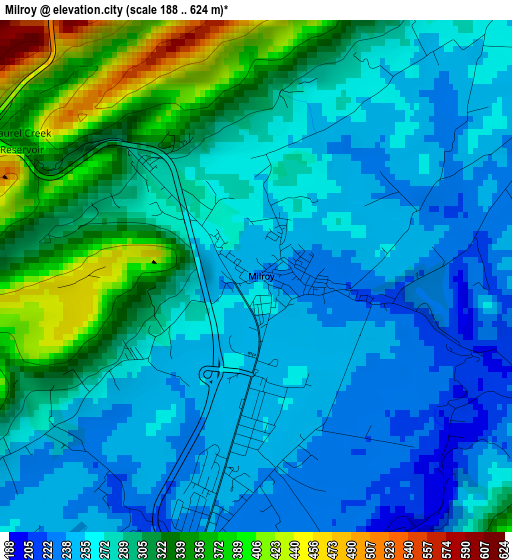
Below is the Elevation map of Milroy, which displays elevation range with different colors. Scale of the first map is from 188 to 624 m (617 to 2047 ft) with average elevation of 286.1 meters (=939 ft) [note 1]
These maps also provides idea of topography and contour of this city, they are displayed at different zoom levels. More info about maps, scale and edge coordinates you can find below images.
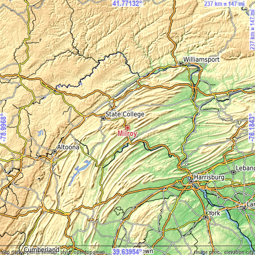
| \ | Map #1 | Topo.Map |
| Scale [m] | 188..624 m | × |
| Scale [ft] | 617..2047 ft | × |
| Average | 286.1 m = 939 ft | × |
| Width | 7.41 km = 4.6 mi | 237 km = 147.3 mi |
| Height | 7.41 km = 4.6 mi | 237 km = 147.3 mi |
| ↑Max Latitude | 40.747261° | 41.77132° |
| Latitude at center | 40.71396° | 40.71396° |
| ↓Min Latitude | 40.680642° | 39.63954° |
| ← Min Longitude | -77.634495° | -78.9968° |
| Longitude center | -77.59055° | -77.59055° |
| →Max Longitude | -77.546605° | -76.1843° |
Nearby cities:
Cities around Milroy sort by population:
• Lewistown elevation 155 m
12.9 km,  172°
172°
• Boalsburg 337 m
18.3 km,  291°
291°
• Pleasant Gap 300 m
21.6 km,  322°
322°
• Lemont 307 m
22 km,  299°
299°
• Burnham 169 m
8.6 km, 167°
• Belleville 242 m
16.6 km,  223°
223°
• Houserville 302 m
23.5 km, 301°
• Church Hill 239 m
3.6 km,  190°
190°
• Highland Park 176 m
10.5 km, 169°
• Centre Hall 406 m
16.9 km,  331°
331°
• Yeagertown 179 m
7.9 km, 173°
• Mifflintown 149 m
22.9 km,  134°
134°
Multilingual:
 En español:
Milroy elevación 238 m.
 En France:
Milroy élévation 238 m.


Sources and notes:
- [note 1] Map square and city borders are not equal. Map elevation data is calculated only from area inside that square.
- [src 1] Elevation data from geonames database provided with same terms of usage.
- [src 2] The elevation map of Milroy is generated using elevation data from NASA's 3 arcsec (90m) resolution SRTM data.
- [src 3] Base (background) map © OpenStreetMap contributors tiles are generated by Geofabrik and OpenTopoMap.
Copyright & License:
This Milroy Elevation Map is licensed under CC BY-SA. You may reuse any part from this page, if you give a proper credit by linking to this URL:
 More info on terms of use page.