Mifflintown elevation
Mifflintown (Pennsylvania, Juniata County), United States elevation is 149 meters and Mifflintown elevation in feet is 489 ft above sea level [src 1]. Mifflintown is a seat of a second-order administrative division (feature code) with elevation that is 130 meters (427 ft) smaller than average city elevation in United States.
Below is the Elevation map of Mifflintown, which displays elevation range with different colors. Scale of the first map is from 127 to 321 m (417 to 1053 ft) with average elevation of 175 meters (=574 ft) [note 1]
These maps also provides idea of topography and contour of this city, they are displayed at different zoom levels. More info about maps, scale and edge coordinates you can find below images.
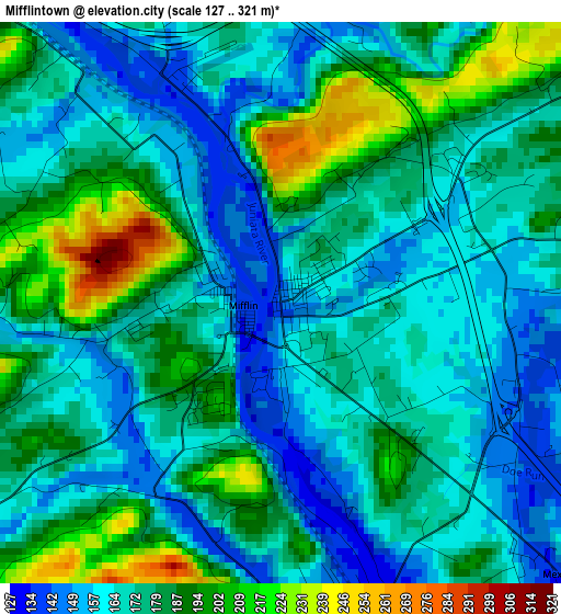
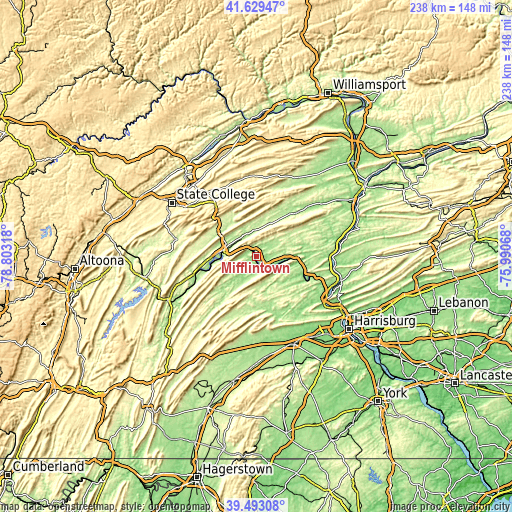
| \ | Map #1 | Topo.Map |
| Scale [m] | 127..321 m | × |
| Scale [ft] | 417..1053 ft | × |
| Average | 175 m = 574 ft | × |
| Width | 7.42 km = 4.6 mi | 237.5 km = 147.6 mi |
| Height | 7.42 km = 4.6 mi | 237.5 km = 147.6 mi |
| ↑Max Latitude | 40.603173° | 41.62947° |
| Latitude at center | 40.5698° | 40.5698° |
| ↓Min Latitude | 40.53641° | 39.49308° |
| ← Min Longitude | -77.440875° | -78.80318° |
| Longitude center | -77.39693° | -77.39693° |
| →Max Longitude | -77.352985° | -75.99068° |
Nearby cities:
Cities around Mifflintown sort by population:
• Lewistown elevation 155 m
15.1 km,  282°
282°
• Millersburg 130 m
37 km,  95°
95°
• Burnham 169 m
16.4 km,  297°
297°
• Belleville 242 m
28 km, 278°
• Church Hill 239 m
21.1 km,  306°
306°
• Newport 121 m
24.7 km,  114°
114°
• Milroy 238 m
22.9 km, 314°
• Duncannon 112 m
36.9 km,  121°
121°
• Highland Park 176 m
15.5 km,  291°
291°
• Middleburg 162 m
38 km,  50°
50°
• New Bloomfield 207 m
24.4 km,  133°
133°
• Yeagertown 179 m
17.5 km, 297°
Multilingual:
 En español:
Mifflintown elevación 149 m.
 En France:
Mifflintown élévation 149 m.
 Auf Deutsch:
Mifflintown höhe über dem Meeresspiegel ist 149 m.

Sources and notes:
- [note 1] Map square and city borders are not equal. Map elevation data is calculated only from area inside that square.
- [src 1] Elevation data from geonames database provided with same terms of usage.
- [src 2] The elevation map of Mifflintown is generated using elevation data from NASA's 3 arcsec (90m) resolution SRTM data.
- [src 3] Base (background) map © OpenStreetMap contributors tiles are generated by Geofabrik and OpenTopoMap.
Copyright & License:
This Mifflintown Elevation Map is licensed under CC BY-SA. You may reuse any part from this page, if you give a proper credit by linking to this URL:
 More info on terms of use page.