Centre Hall elevation
Centre Hall (Pennsylvania, Centre County), United States elevation is 406 meters and Centre Hall elevation in feet is 1332 ft above sea level [src 1]. Centre Hall is a populated place (feature code) with elevation that is 127 meters (417 ft) bigger than average city elevation in United States.
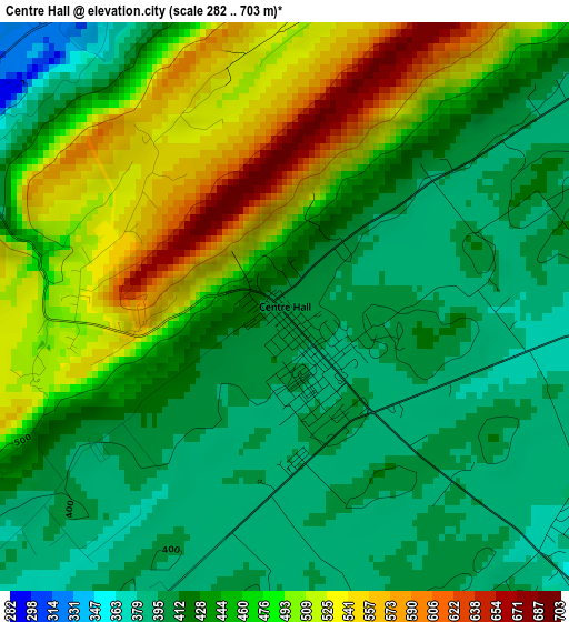
Below is the Elevation map of Centre Hall, which displays elevation range with different colors. Scale of the first map is from 282 to 703 m (925 to 2306 ft) with average elevation of 450.3 meters (=1477 ft) [note 1]
These maps also provides idea of topography and contour of this city, they are displayed at different zoom levels. More info about maps, scale and edge coordinates you can find below images.
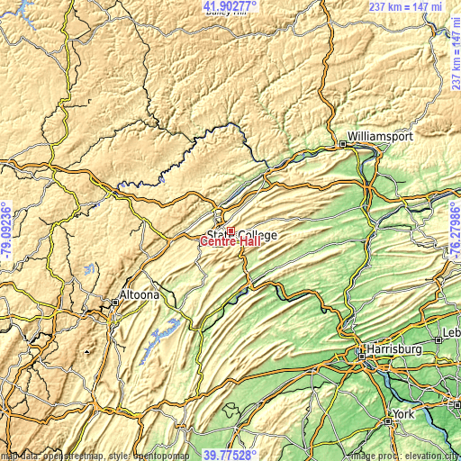
| \ | Map #1 | Topo.Map |
| Scale [m] | 282..703 m | × |
| Scale [ft] | 925..2306 ft | × |
| Average | 450.3 m = 1477 ft | × |
| Width | 7.39 km = 4.6 mi | 236.6 km = 147 mi |
| Height | 7.39 km = 4.6 mi | 236.5 km = 147 mi |
| ↑Max Latitude | 40.880794° | 41.90277° |
| Latitude at center | 40.84756° | 40.84756° |
| ↓Min Latitude | 40.814309° | 39.77528° |
| ← Min Longitude | -77.730055° | -79.09236° |
| Longitude center | -77.68611° | -77.68611° |
| →Max Longitude | -77.642165° | -76.27986° |
Nearby cities:
Cities around Centre Hall sort by population:
• State College elevation 351 m
15.8 km,  247°
247°
• Park Forest Village 391 m
19.9 km,  256°
256°
• Bellefonte 240 m
10.7 km,  313°
313°
• Boalsburg 337 m
12 km,  228°
228°
• Pleasant Gap 300 m
5.6 km,  294°
294°
• Lemont 307 m
11.9 km, 249°
• Toftrees 364 m
16.6 km, 261°
• Zion 311 m
7.4 km,  0°
0°
• Houserville 302 m
12.3 km, 257°
• Church Hill 239 m
19.8 km,  158°
158°
• Milroy 238 m
16.9 km,  151°
151°
• Milesburg 214 m
13.4 km,  321°
321°
Multilingual:
 En español:
Centre Hall elevación 406 m.
 En France:
Centre Hall élévation 406 m.
 Auf Deutsch:
Centre Hall höhe über dem Meeresspiegel ist 406 m.

Sources and notes:
- [note 1] Map square and city borders are not equal. Map elevation data is calculated only from area inside that square.
- [src 1] Elevation data from geonames database provided with same terms of usage.
- [src 2] The elevation map of Centre Hall is generated using elevation data from NASA's 3 arcsec (90m) resolution SRTM data.
- [src 3] Base (background) map © OpenStreetMap contributors tiles are generated by Geofabrik and OpenTopoMap.
Copyright & License:
This Centre Hall Elevation Map is licensed under CC BY-SA. You may reuse any part from this page, if you give a proper credit by linking to this URL:
 More info on terms of use page.