Maytown elevation
Maytown (Pennsylvania, Lancaster County), United States elevation is 125 meters and Maytown elevation in feet is 410 ft above sea level [src 1]. Maytown is a populated place (feature code) with elevation that is 154 meters (505 ft) smaller than average city elevation in United States.
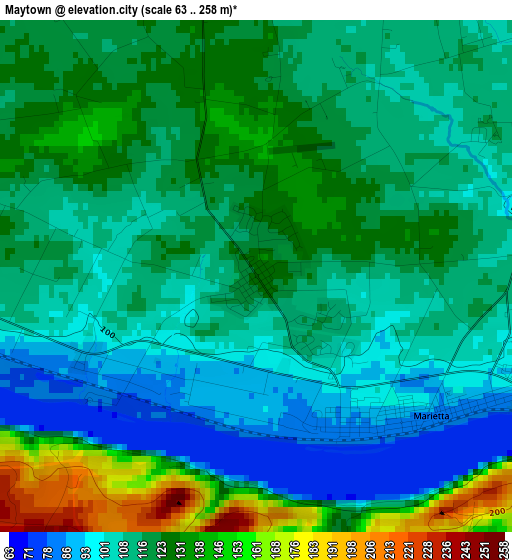
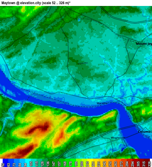
Below is the Elevation map of Maytown, which displays elevation range with different colors. Scale of the first map is from 63 to 258 m (207 to 846 ft) with average elevation of 116.6 meters (=383 ft) [note 1]
These maps also provides idea of topography and contour of this city, they are displayed at different zoom levels. More info about maps, scale and edge coordinates you can find below images.
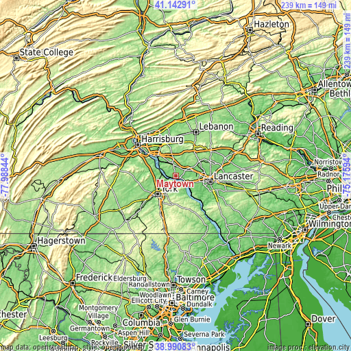
| \ | Map #1 | Map #2 | Topo.Map |
| Scale [m] | 63..258 m | 52..326 m | × |
| Scale [ft] | 207..846 ft | 171..1070 ft | × |
| Average | 116.6 m = 383 ft | 129.3 m = 424 ft | × |
| Width | 7.48 km = 4.6 mi | 14.96 km = 9.3 mi | 239.3 km = 148.7 mi |
| Height | 7.48 km = 4.6 mi | 14.96 km = 9.3 mi | 239.3 km = 148.7 mi |
| ↑Max Latitude | 40.108989° | 40.142591° | 41.14291° |
| Latitude at center | 40.07537° | 40.07537° | 40.07537° |
| ↓Min Latitude | 40.041735° | 40.008083° | 38.99083° |
| ← Min Longitude | -76.626135° | -76.670081° | -77.98844° |
| Longitude center | -76.58219° | -76.58219° | -76.58219° |
| →Max Longitude | -76.538245° | -76.494299° | -75.17594° |
Nearby cities:
Cities around Maytown sort by population:
• Elizabethtown elevation 140 m
8.8 km,  348°
348°
• Columbia 93 m
8.1 km,  124°
124°
• Mount Joy 116 m
7.7 km,  60°
60°
• Manchester 154 m
11.7 km,  263°
263°
• Hallam 115 m
8.1 km,  193°
193°
• Marietta 83 m
3.3 km,  128°
128°
• Stonybrook 123 m
11.1 km,  208°
208°
• Wrightsville 92 m
7.1 km,  141°
141°
• Yorklyn 134 m
10.7 km, 210°
• Rheems 130 m
6.2 km,  9°
9°
• Mount Wolf 132 m
10.4 km, 262°
• Bainbridge 94 m
7.5 km,  283°
283°
Multilingual:
 En español:
Maytown elevación 125 m.
 En France:
Maytown élévation 125 m.


Sources and notes:
- [note 1] Map square and city borders are not equal. Map elevation data is calculated only from area inside that square.
- [src 1] Elevation data from geonames database provided with same terms of usage.
- [src 2] The elevation map of Maytown is generated using elevation data from NASA's 3 arcsec (90m) resolution SRTM data.
- [src 3] Base (background) map © OpenStreetMap contributors tiles are generated by Geofabrik and OpenTopoMap.
Copyright & License:
This Maytown Elevation Map is licensed under CC BY-SA. You may reuse any part from this page, if you give a proper credit by linking to this URL:
 More info on terms of use page.