Hallam elevation
Hallam (Pennsylvania, York County), United States elevation is 115 meters and Hallam elevation in feet is 377 ft above sea level [src 1]. Hallam is a populated place (feature code) with elevation that is 164 meters (538 ft) smaller than average city elevation in United States.
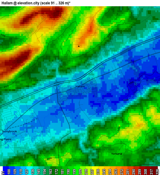
Below is the Elevation map of Hallam, which displays elevation range with different colors. Scale of the first map is from 91 to 326 m (299 to 1070 ft) with average elevation of 168.1 meters (=552 ft) [note 1]
These maps also provides idea of topography and contour of this city, they are displayed at different zoom levels. More info about maps, scale and edge coordinates you can find below images.
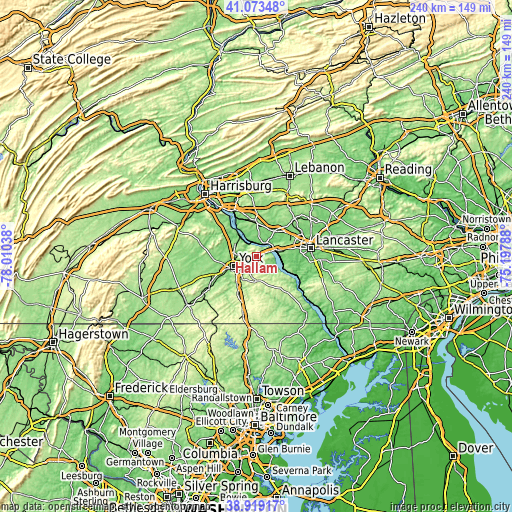
| \ | Map #1 | Topo.Map |
| Scale [m] | 91..326 m | × |
| Scale [ft] | 299..1070 ft | × |
| Average | 168.1 m = 552 ft | × |
| Width | 7.49 km = 4.7 mi | 239.5 km = 148.8 mi |
| Height | 7.49 km = 4.7 mi | 239.5 km = 148.8 mi |
| ↑Max Latitude | 40.038473° | 41.07348° |
| Latitude at center | 40.00482° | 40.00482° |
| ↓Min Latitude | 39.97115° | 38.91917° |
| ← Min Longitude | -76.648075° | -78.01038° |
| Longitude center | -76.60413° | -76.60413° |
| →Max Longitude | -76.560185° | -75.19788° |
Nearby cities:
Cities around Hallam sort by population:
• Columbia elevation 93 m
9.1 km,  69°
69°
• East York 129 m
7.8 km,  243°
243°
• Maytown 125 m
8.1 km,  13°
13°
• Valley View 187 m
10.3 km,  233°
233°
• Emigsville 131 m
10.7 km,  280°
280°
• Marietta 83 m
7.3 km,  37°
37°
• Stonybrook 123 m
3.9 km, 239°
• Wrightsville 92 m
6.7 km, 69°
• Yorklyn 134 m
3.9 km,  248°
248°
• Windsor 210 m
10 km,  170°
170°
• Mount Wolf 132 m
10.7 km,  307°
307°
• Yoe 219 m
11 km,  194°
194°
Multilingual:
 En español:
Hallam elevación 115 m.
 En France:
Hallam élévation 115 m.


Sources and notes:
- [note 1] Map square and city borders are not equal. Map elevation data is calculated only from area inside that square.
- [src 1] Elevation data from geonames database provided with same terms of usage.
- [src 2] The elevation map of Hallam is generated using elevation data from NASA's 3 arcsec (90m) resolution SRTM data.
- [src 3] Base (background) map © OpenStreetMap contributors tiles are generated by Geofabrik and OpenTopoMap.
Copyright & License:
This Hallam Elevation Map is licensed under CC BY-SA. You may reuse any part from this page, if you give a proper credit by linking to this URL:
 More info on terms of use page.