Bainbridge elevation
Bainbridge (Pennsylvania, Lancaster County), United States elevation is 94 meters and Bainbridge elevation in feet is 308 ft above sea level [src 1]. Bainbridge is a populated place (feature code) with elevation that is 185 meters (607 ft) smaller than average city elevation in United States.
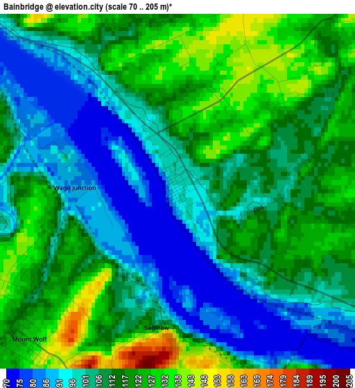
Below is the Elevation map of Bainbridge, which displays elevation range with different colors. Scale of the first map is from 70 to 205 m (230 to 673 ft) with average elevation of 109.8 meters (=360 ft) [note 1]
These maps also provides idea of topography and contour of this city, they are displayed at different zoom levels. More info about maps, scale and edge coordinates you can find below images.
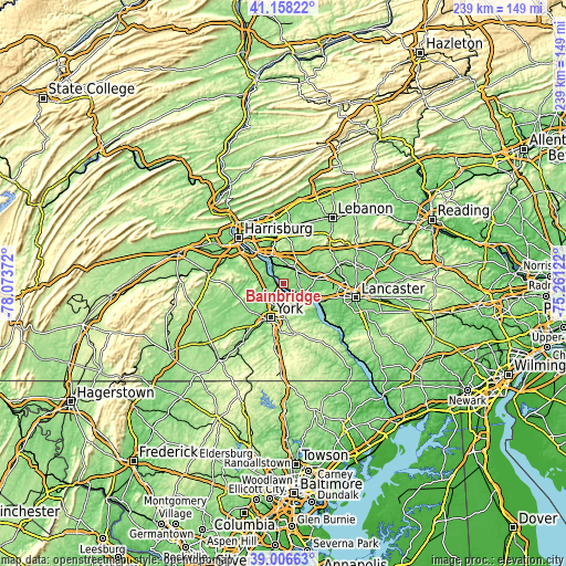
| \ | Map #1 | Topo.Map |
| Scale [m] | 70..205 m | × |
| Scale [ft] | 230..673 ft | × |
| Average | 109.8 m = 360 ft | × |
| Width | 7.48 km = 4.6 mi | 239.2 km = 148.6 mi |
| Height | 7.48 km = 4.6 mi | 239.2 km = 148.6 mi |
| ↑Max Latitude | 40.124541° | 41.15822° |
| Latitude at center | 40.09093° | 40.09093° |
| ↓Min Latitude | 40.057303° | 39.00663° |
| ← Min Longitude | -76.711415° | -78.07372° |
| Longitude center | -76.66747° | -76.66747° |
| →Max Longitude | -76.623525° | -75.26122° |
Nearby cities:
Cities around Bainbridge sort by population:
• Elizabethtown elevation 140 m
8.8 km,  38°
38°
• Maytown 125 m
7.5 km,  103°
103°
• Valley Green 115 m
13 km,  304°
304°
• Manchester 154 m
5.3 km,  234°
234°
• Emigsville 131 m
9.3 km,  213°
213°
• Hallam 115 m
11 km,  150°
150°
• Marietta 83 m
10.5 km,  111°
111°
• Stonybrook 123 m
11.7 km,  170°
170°
• Yorklyn 134 m
11.1 km, 170°
• Rheems 130 m
9.3 km,  62°
62°
• Mount Wolf 132 m
4.4 km, 225°
• Royalton 94 m
12 km,  333°
333°
Multilingual:
 En español:
Bainbridge elevación 94 m.
 En France:
Bainbridge élévation 94 m.
 Auf Deutsch:
Bainbridge höhe über dem Meeresspiegel ist 94 m.

Sources and notes:
- [note 1] Map square and city borders are not equal. Map elevation data is calculated only from area inside that square.
- [src 1] Elevation data from geonames database provided with same terms of usage.
- [src 2] The elevation map of Bainbridge is generated using elevation data from NASA's 3 arcsec (90m) resolution SRTM data.
- [src 3] Base (background) map © OpenStreetMap contributors tiles are generated by Geofabrik and OpenTopoMap.
Copyright & License:
This Bainbridge Elevation Map is licensed under CC BY-SA. You may reuse any part from this page, if you give a proper credit by linking to this URL:
 More info on terms of use page.