Marianne elevation
Marianne (Pennsylvania, Clarion County), United States elevation is 447 meters and Marianne elevation in feet is 1467 ft above sea level [src 1]. Marianne is a populated place (feature code) with elevation that is 168 meters (551 ft) bigger than average city elevation in United States.
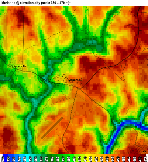
Below is the Elevation map of Marianne, which displays elevation range with different colors. Scale of the first map is from 330 to 479 m (1083 to 1572 ft) with average elevation of 424.2 meters (=1392 ft) [note 1]
These maps also provides idea of topography and contour of this city, they are displayed at different zoom levels. More info about maps, scale and edge coordinates you can find below images.
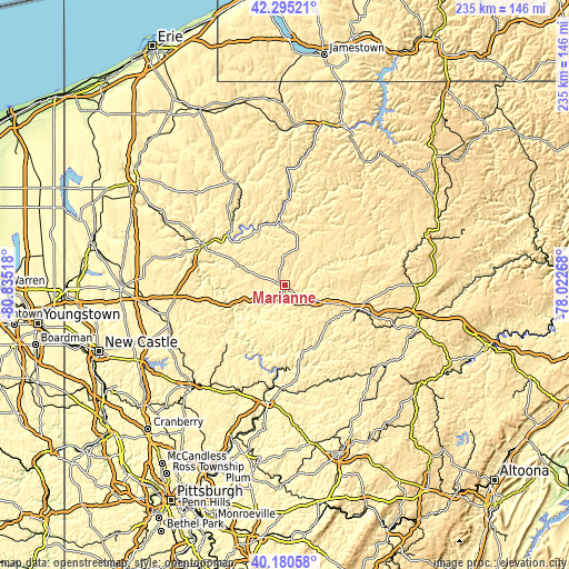
| \ | Map #1 | Topo.Map |
| Scale [m] | 330..479 m | × |
| Scale [ft] | 1083..1572 ft | × |
| Average | 424.2 m = 1392 ft | × |
| Width | 7.35 km = 4.6 mi | 235.1 km = 146.1 mi |
| Height | 7.35 km = 4.6 mi | 235.1 km = 146.1 mi |
| ↑Max Latitude | 41.279483° | 42.29521° |
| Latitude at center | 41.24645° | 41.24645° |
| ↓Min Latitude | 41.2134° | 40.18058° |
| ← Min Longitude | -79.472875° | -80.83518° |
| Longitude center | -79.42893° | -79.42893° |
| →Max Longitude | -79.384985° | -78.02268° |
Nearby cities:
Cities around Marianne sort by population:
• Oil City elevation 314 m
31.2 km,  311°
311°
• Franklin 310 m
37.6 km,  296°
296°
• Clarion 456 m
5.1 km,  133°
133°
• Sugarcreek 318 m
42.5 km, 297°
• Brookville 388 m
30.4 km,  108°
108°
• Marienville 530 m
35.5 km,  45°
45°
• Hasson Heights 455 m
30.6 km,  317°
317°
• Woodland Heights 430 m
29.8 km, 307°
• Knox 428 m
9.2 km,  261°
261°
• Seneca 443 m
27.3 km, 302°
• Chicora 372 m
42.3 km,  218°
218°
• Tionesta 335 m
27.8 km,  355°
355°
Multilingual:
 En español:
Marianne elevación 447 m.
 En France:
Marianne élévation 447 m.
 Auf Deutsch:
Marianne höhe über dem Meeresspiegel ist 447 m.

Sources and notes:
- [note 1] Map square and city borders are not equal. Map elevation data is calculated only from area inside that square.
- [src 1] Elevation data from geonames database provided with same terms of usage.
- [src 2] The elevation map of Marianne is generated using elevation data from NASA's 3 arcsec (90m) resolution SRTM data.
- [src 3] Base (background) map © OpenStreetMap contributors tiles are generated by Geofabrik and OpenTopoMap.
Copyright & License:
This Marianne Elevation Map is licensed under CC BY-SA. You may reuse any part from this page, if you give a proper credit by linking to this URL:
 More info on terms of use page.