Clarion elevation
Clarion (Pennsylvania, Clarion County), United States elevation is 456 meters and Clarion elevation in feet is 1496 ft above sea level [src 1]. Clarion is a seat of a second-order administrative division (feature code) with elevation that is 177 meters (581 ft) bigger than average city elevation in United States.
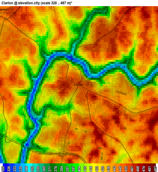
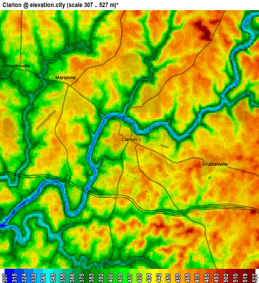
Below is the Elevation map of Clarion, which displays elevation range with different colors. Scale of the first map is from 320 to 487 m (1050 to 1598 ft) with average elevation of 428.1 meters (=1405 ft) [note 1]
These maps also provides idea of topography and contour of this city, they are displayed at different zoom levels. More info about maps, scale and edge coordinates you can find below images.
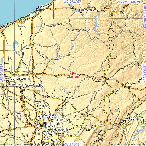
| \ | Map #1 | Map #2 | Topo.Map |
| Scale [m] | 320..487 m | 307..527 m | × |
| Scale [ft] | 1050..1598 ft | 1007..1729 ft | × |
| Average | 428.1 m = 1405 ft | 428.7 m = 1406 ft | × |
| Width | 7.35 km = 4.6 mi | 14.7 km = 9.1 mi | 235.2 km = 146.1 mi |
| Height | 7.35 km = 4.6 mi | 14.7 km = 9.1 mi | 235.2 km = 146.1 mi |
| ↑Max Latitude | 41.247839° | 41.280872° | 42.26407° |
| Latitude at center | 41.21479° | 41.21479° | 41.21479° |
| ↓Min Latitude | 41.181724° | 41.148641° | 40.14841° |
| ← Min Longitude | -79.429265° | -79.473211° | -80.79157° |
| Longitude center | -79.38532° | -79.38532° | -79.38532° |
| →Max Longitude | -79.341375° | -79.297429° | -77.97907° |
Nearby cities:
Cities around Clarion sort by population:
• Oil City elevation 314 m
36.2 km,  312°
312°
• Franklin 310 m
42.5 km,  298°
298°
• Brookville 388 m
26 km,  103°
103°
• Marienville 530 m
35.7 km,  37°
37°
• Reynoldsville 422 m
43.6 km,  107°
107°
• Hasson Heights 455 m
35.7 km,  316°
316°
• Woodland Heights 430 m
34.8 km, 308°
• Marianne 447 m
5.1 km, 313°
• Knox 428 m
12.9 km,  279°
279°
• Seneca 443 m
32.3 km, 304°
• Chicora 372 m
42.2 km,  225°
225°
• Tionesta 335 m
31.7 km,  349°
349°
Multilingual:
 En español:
Clarion elevación 456 m.
 En France:
Clarion élévation 456 m.


Sources and notes:
- [note 1] Map square and city borders are not equal. Map elevation data is calculated only from area inside that square.
- [src 1] Elevation data from geonames database provided with same terms of usage.
- [src 2] The elevation map of Clarion is generated using elevation data from NASA's 3 arcsec (90m) resolution SRTM data.
- [src 3] Base (background) map © OpenStreetMap contributors tiles are generated by Geofabrik and OpenTopoMap.
Copyright & License:
This Clarion Elevation Map is licensed under CC BY-SA. You may reuse any part from this page, if you give a proper credit by linking to this URL:
 More info on terms of use page.