Laporte elevation
Laporte (Pennsylvania, Sullivan County), United States elevation is 600 meters and Laporte elevation in feet is 1969 ft above sea level [src 1]. Laporte is a seat of a second-order administrative division (feature code) with elevation that is 321 meters (1053 ft) bigger than average city elevation in United States.
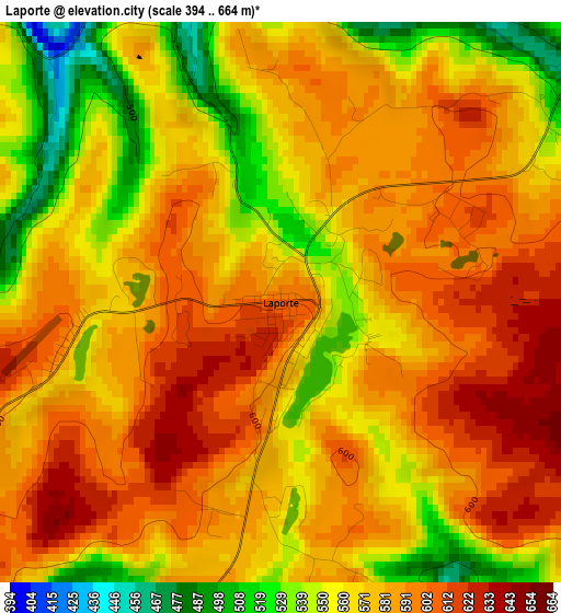
Below is the Elevation map of Laporte, which displays elevation range with different colors. Scale of the first map is from 394 to 664 m (1293 to 2178 ft) with average elevation of 575.3 meters (=1887 ft) [note 1]
These maps also provides idea of topography and contour of this city, they are displayed at different zoom levels. More info about maps, scale and edge coordinates you can find below images.
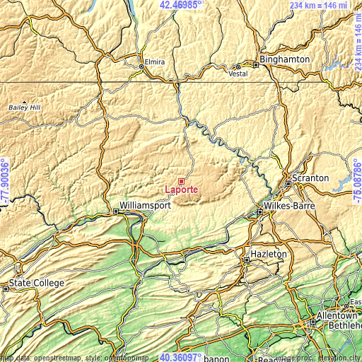
| \ | Map #1 | Topo.Map |
| Scale [m] | 394..664 m | × |
| Scale [ft] | 1293..2178 ft | × |
| Average | 575.3 m = 1887 ft | × |
| Width | 7.33 km = 4.6 mi | 234.5 km = 145.7 mi |
| Height | 7.33 km = 4.6 mi | 234.5 km = 145.7 mi |
| ↑Max Latitude | 41.456913° | 42.46985° |
| Latitude at center | 41.42397° | 41.42397° |
| ↓Min Latitude | 41.39101° | 40.36097° |
| ← Min Longitude | -76.538055° | -77.90036° |
| Longitude center | -76.49411° | -76.49411° |
| →Max Longitude | -76.450165° | -75.08786° |
Nearby cities:
Cities around Laporte sort by population:
• Back Mountain elevation 392 m
42.7 km,  103°
103°
• Montoursville 165 m
40.3 km,  242°
242°
• Kenmar 162 m
43.2 km, 243°
• Towanda 223 m
38.4 km,  6°
6°
• Harveys Lake 412 m
39.4 km, 96°
• Muncy 152 m
34.4 km,  225°
225°
• Hughesville 178 m
27.9 km,  223°
223°
• Canton 377 m
39.5 km,  310°
310°
• Glen Lyon 208 m
44.6 km,  128°
128°
• Montgomery 154 m
42.6 km, 228°
• Faxon 161 m
44.8 km, 244°
• Light Street 167 m
43.5 km,  172°
172°
Multilingual:
 En español:
Laporte elevación 600 m.
 En France:
Laporte élévation 600 m.


Sources and notes:
- [note 1] Map square and city borders are not equal. Map elevation data is calculated only from area inside that square.
- [src 1] Elevation data from geonames database provided with same terms of usage.
- [src 2] The elevation map of Laporte is generated using elevation data from NASA's 3 arcsec (90m) resolution SRTM data.
- [src 3] Base (background) map © OpenStreetMap contributors tiles are generated by Geofabrik and OpenTopoMap.
Copyright & License:
This Laporte Elevation Map is licensed under CC BY-SA. You may reuse any part from this page, if you give a proper credit by linking to this URL:
 More info on terms of use page.