Harveys Lake elevation
Harveys Lake (Pennsylvania, Luzerne County), United States elevation is 412 meters and Harveys Lake elevation in feet is 1352 ft above sea level [src 1]. Harveys Lake is a populated place (feature code) with elevation that is 133 meters (436 ft) bigger than average city elevation in United States.
Below is the Elevation map of Harveys Lake, which displays elevation range with different colors. Scale of the first map is from 290 to 523 m (951 to 1716 ft) with average elevation of 403.4 meters (=1323 ft) [note 1]
These maps also provides idea of topography and contour of this city, they are displayed at different zoom levels. More info about maps, scale and edge coordinates you can find below images.
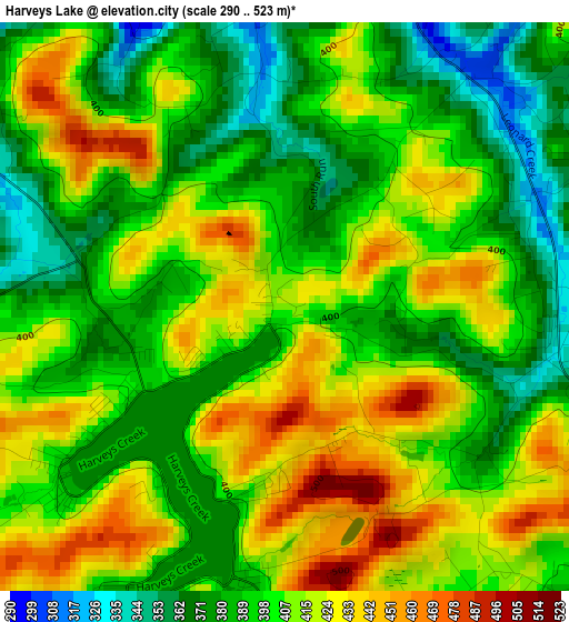
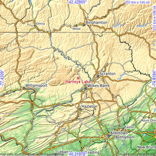
| \ | Map #1 | Topo.Map |
| Scale [m] | 290..523 m | × |
| Scale [ft] | 951..1716 ft | × |
| Average | 403.4 m = 1323 ft | × |
| Width | 7.33 km = 4.6 mi | 234.6 km = 145.8 mi |
| Height | 7.33 km = 4.6 mi | 234.6 km = 145.8 mi |
| ↑Max Latitude | 41.416374° | 42.42995° |
| Latitude at center | 41.38341° | 41.38341° |
| ↓Min Latitude | 41.350429° | 40.31975° |
| ← Min Longitude | -76.068595° | -77.4309° |
| Longitude center | -76.02465° | -76.02465° |
| →Max Longitude | -75.980705° | -74.6184° |
Nearby cities:
Cities around Harveys Lake sort by population:
• Back Mountain elevation 392 m
5.8 km,  155°
155°
• Kingston 166 m
17.2 km,  141°
141°
• Plymouth 164 m
17.3 km, 157°
• Swoyersville 167 m
16.1 km,  129°
129°
• Edwardsville 216 m
15.6 km, 144°
• Larksville 170 m
17.3 km,  152°
152°
• Forty Fort 168 m
16.9 km, 133°
• Luzerne 190 m
15 km, 136°
• Dallas 346 m
7.3 km, 135°
• West Wyoming 186 m
16.5 km,  115°
115°
• Trucksville 278 m
11.7 km, 138°
• Shavertown 315 m
10.1 km, 134°
Multilingual:
 En español:
Harveys Lake elevación 412 m.
 En France:
Harveys Lake élévation 412 m.
 Auf Deutsch:
Harveys Lake höhe über dem Meeresspiegel ist 412 m.

Sources and notes:
- [note 1] Map square and city borders are not equal. Map elevation data is calculated only from area inside that square.
- [src 1] Elevation data from geonames database provided with same terms of usage.
- [src 2] The elevation map of Harveys Lake is generated using elevation data from NASA's 3 arcsec (90m) resolution SRTM data.
- [src 3] Base (background) map © OpenStreetMap contributors tiles are generated by Geofabrik and OpenTopoMap.
Copyright & License:
This Harveys Lake Elevation Map is licensed under CC BY-SA. You may reuse any part from this page, if you give a proper credit by linking to this URL:
 More info on terms of use page.