Kenmar elevation
Kenmar (Pennsylvania, Lycoming County), United States elevation is 162 meters and Kenmar elevation in feet is 531 ft above sea level [src 1]. Kenmar is a populated place (feature code) with elevation that is 117 meters (384 ft) smaller than average city elevation in United States.
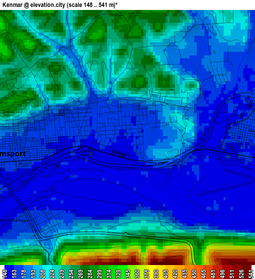
Below is the Elevation map of Kenmar, which displays elevation range with different colors. Scale of the first map is from 148 to 541 m (486 to 1775 ft) with average elevation of 211.2 meters (=693 ft) [note 1]
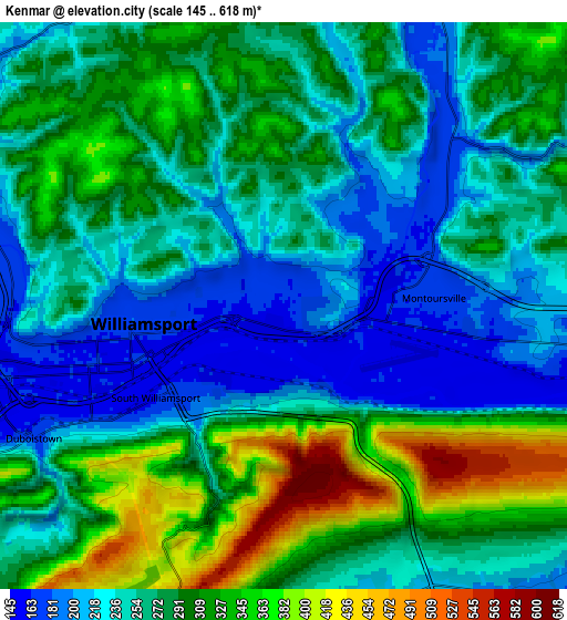
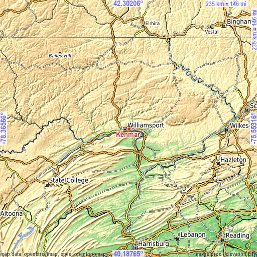
These maps also provides idea of topography and contour of this city, they are displayed at different zoom levels. More info about maps, scale and edge coordinates you can find below images.
| \ | Map #1 | Map #2 | Topo.Map |
| Scale [m] | 148..541 m | 145..618 m | × |
| Scale [ft] | 486..1775 ft | 476..2028 ft | × |
| Average | 211.2 m = 693 ft | 275.6 m = 904 ft | × |
| Width | 7.35 km = 4.6 mi | 14.69 km = 9.1 mi | 235.1 km = 146.1 mi |
| Height | 7.35 km = 4.6 mi | 14.69 km = 9.1 mi | 235.1 km = 146.1 mi |
| ↑Max Latitude | 41.28644° | 41.319453° | 42.30206° |
| Latitude at center | 41.25341° | 41.25341° | 41.25341° |
| ↓Min Latitude | 41.220364° | 41.1873° | 40.18765° |
| ← Min Longitude | -77.003355° | -77.047301° | -78.36566° |
| Longitude center | -76.95941° | -76.95941° | -76.95941° |
| →Max Longitude | -76.915465° | -76.871519° | -75.55316° |
Nearby cities:
Cities around Kenmar sort by population:
• Williamsport elevation 162 m
3.7 km,  248°
248°
• South Williamsport 165 m
4.1 km,  234°
234°
• Montoursville 165 m
3.3 km,  88°
88°
• Garden View 169 m
7.2 km,  270°
270°
• Muncy 152 m
15.5 km,  110°
110°
• Watsontown 149 m
20.4 km,  156°
156°
• Hughesville 178 m
19.7 km, 93°
• Montgomery 154 m
11.5 km,  143°
143°
• Dewart 148 m
17.5 km, 156°
• Faxon 161 m
1.6 km, 249°
• Duboistown 164 m
7.3 km,  242°
242°
• New Columbia 145 m
24.9 km, 161°
Multilingual:
 En español:
Kenmar elevación 162 m.
 En France:
Kenmar élévation 162 m.


Sources and notes:
- [note 1] Map square and city borders are not equal. Map elevation data is calculated only from area inside that square.
- [src 1] Elevation data from geonames database provided with same terms of usage.
- [src 2] The elevation map of Kenmar is generated using elevation data from NASA's 3 arcsec (90m) resolution SRTM data.
- [src 3] Base (background) map © OpenStreetMap contributors tiles are generated by Geofabrik and OpenTopoMap.
Copyright & License:
This Kenmar Elevation Map is licensed under CC BY-SA. You may reuse any part from this page, if you give a proper credit by linking to this URL:
 More info on terms of use page.