Indiana elevation
Indiana (Pennsylvania, Indiana County), United States elevation is 403 meters and Indiana elevation in feet is 1322 ft above sea level [src 1]. Indiana is a seat of a second-order administrative division (feature code) with elevation that is 124 meters (407 ft) bigger than average city elevation in United States.
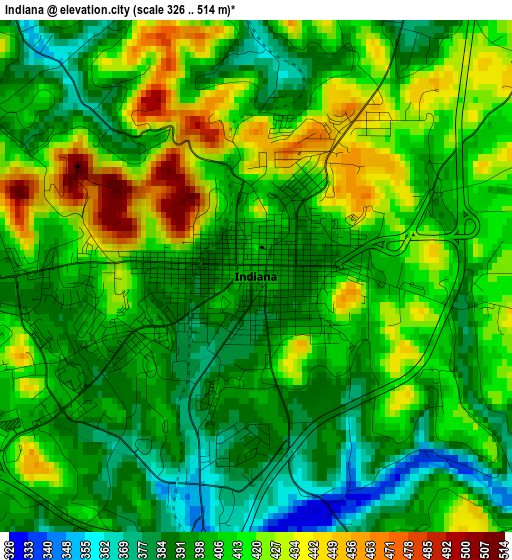
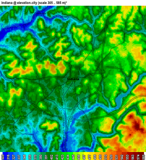
Below is the Elevation map of Indiana, which displays elevation range with different colors. Scale of the first map is from 326 to 514 m (1070 to 1686 ft) with average elevation of 406.7 meters (=1334 ft) [note 1]
These maps also provides idea of topography and contour of this city, they are displayed at different zoom levels. More info about maps, scale and edge coordinates you can find below images.
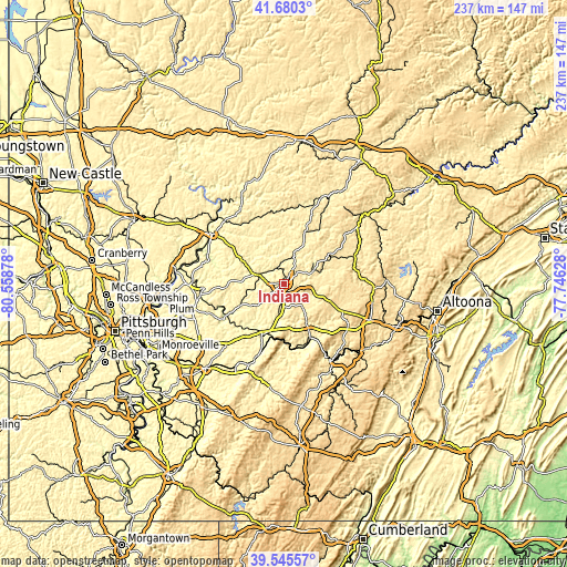
| \ | Map #1 | Map #2 | Topo.Map |
| Scale [m] | 326..514 m | 305..585 m | × |
| Scale [ft] | 1070..1686 ft | 1001..1919 ft | × |
| Average | 406.7 m = 1334 ft | 409.1 m = 1342 ft | × |
| Width | 7.42 km = 4.6 mi | 14.84 km = 9.2 mi | 237.4 km = 147.5 mi |
| Height | 7.42 km = 4.6 mi | 14.84 km = 9.2 mi | 237.4 km = 147.5 mi |
| ↑Max Latitude | 40.654807° | 40.688138° | 41.6803° |
| Latitude at center | 40.62146° | 40.62146° | 40.62146° |
| ↓Min Latitude | 40.588096° | 40.554715° | 39.54557° |
| ← Min Longitude | -79.196475° | -79.240421° | -80.55878° |
| Longitude center | -79.15253° | -79.15253° | -79.15253° |
| →Max Longitude | -79.108585° | -79.064639° | -77.74628° |
Nearby cities:
Cities around Indiana sort by population:
• Northern Cambria elevation 462 m
31.6 km,  82°
82°
• Blairsville 309 m
23.1 km,  203°
203°
• Nanty Glo 536 m
31.7 km,  121°
121°
• Barnesboro 446 m
31.8 km, 81°
• Orchard Hills 348 m
32.2 km,  263°
263°
• Spangler 450 m
32.1 km,  85°
85°
• Homer City 311 m
8.7 km,  185°
185°
• Mundys Corner 576 m
32.8 km,  126°
126°
• Chevy Chase Heights 435 m
1.8 km,  22°
22°
• Black Lick 320 m
16.8 km, 189°
• Clymer 381 m
13 km,  66°
66°
• North Apollo 251 m
34.1 km,  265°
265°
Multilingual:
 En español:
Indiana elevación 403 m.
 En France:
Indiana élévation 403 m.


Sources and notes:
- [note 1] Map square and city borders are not equal. Map elevation data is calculated only from area inside that square.
- [src 1] Elevation data from geonames database provided with same terms of usage.
- [src 2] The elevation map of Indiana is generated using elevation data from NASA's 3 arcsec (90m) resolution SRTM data.
- [src 3] Base (background) map © OpenStreetMap contributors tiles are generated by Geofabrik and OpenTopoMap.
Copyright & License:
This Indiana Elevation Map is licensed under CC BY-SA. You may reuse any part from this page, if you give a proper credit by linking to this URL:
 More info on terms of use page.