Spangler elevation
Spangler (Pennsylvania, Cambria County), United States elevation is 450 meters and Spangler elevation in feet is 1476 ft above sea level [src 1]. Spangler is a populated place (feature code) with elevation that is 171 meters (561 ft) bigger than average city elevation in United States.
Below is the Elevation map of Spangler, which displays elevation range with different colors. Scale of the first map is from 436 to 677 m (1430 to 2221 ft) with average elevation of 528.7 meters (=1735 ft) [note 1]
These maps also provides idea of topography and contour of this city, they are displayed at different zoom levels. More info about maps, scale and edge coordinates you can find below images.
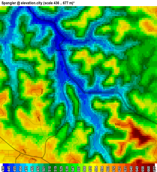
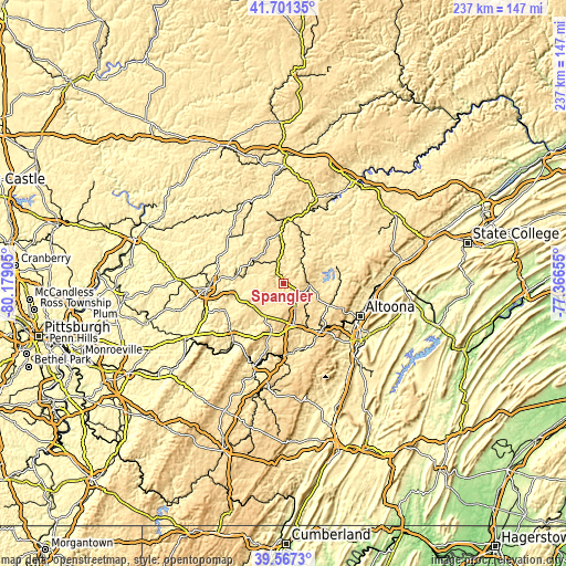
| \ | Map #1 | Topo.Map |
| Scale [m] | 436..677 m | × |
| Scale [ft] | 1430..2221 ft | × |
| Average | 528.7 m = 1735 ft | × |
| Width | 7.42 km = 4.6 mi | 237.3 km = 147.5 mi |
| Height | 7.42 km = 4.6 mi | 237.3 km = 147.5 mi |
| ↑Max Latitude | 40.676187° | 41.70135° |
| Latitude at center | 40.64285° | 40.64285° |
| ↓Min Latitude | 40.609497° | 39.5673° |
| ← Min Longitude | -78.816745° | -80.17905° |
| Longitude center | -78.7728° | -78.7728° |
| →Max Longitude | -78.728855° | -77.36655° |
Nearby cities:
Cities around Spangler sort by population:
• Northern Cambria elevation 462 m
2 km,  337°
337°
• Ebensburg 652 m
18 km,  166°
166°
• Nanty Glo 536 m
19.6 km,  195°
195°
• Barnesboro 446 m
2.3 km, 344°
• Patton 539 m
10.4 km,  95°
95°
• Mundys Corner 576 m
22.8 km,  194°
194°
• Cresson 617 m
25.5 km,  143°
143°
• Gallitzin 667 m
25.8 km,  133°
133°
• Loretto 592 m
19.7 km, 142°
• Clymer 381 m
20.3 km,  277°
277°
• Vinco 530 m
27.3 km, 194°
• Hastings 529 m
5.7 km,  64°
64°
Multilingual:
 En español:
Spangler elevación 450 m.
 En France:
Spangler élévation 450 m.
 Auf Deutsch:
Spangler höhe über dem Meeresspiegel ist 450 m.

Sources and notes:
- [note 1] Map square and city borders are not equal. Map elevation data is calculated only from area inside that square.
- [src 1] Elevation data from geonames database provided with same terms of usage.
- [src 2] The elevation map of Spangler is generated using elevation data from NASA's 3 arcsec (90m) resolution SRTM data.
- [src 3] Base (background) map © OpenStreetMap contributors tiles are generated by Geofabrik and OpenTopoMap.
Copyright & License:
This Spangler Elevation Map is licensed under CC BY-SA. You may reuse any part from this page, if you give a proper credit by linking to this URL:
 More info on terms of use page.