Elverson elevation
Elverson (Pennsylvania, Chester County), United States elevation is 209 meters and Elverson elevation in feet is 686 ft above sea level [src 1]. Elverson is a populated place (feature code) with elevation that is 70 meters (230 ft) smaller than average city elevation in United States.
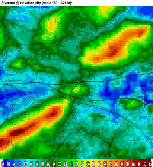
Below is the Elevation map of Elverson, which displays elevation range with different colors. Scale of the first map is from 150 to 321 m (492 to 1053 ft) with average elevation of 205.2 meters (=673 ft) [note 1]
These maps also provides idea of topography and contour of this city, they are displayed at different zoom levels. More info about maps, scale and edge coordinates you can find below images.
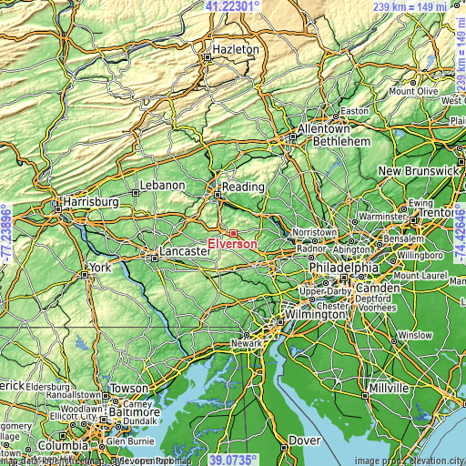
| \ | Map #1 | Topo.Map |
| Scale [m] | 150..321 m | × |
| Scale [ft] | 492..1053 ft | × |
| Average | 205.2 m = 673 ft | × |
| Width | 7.47 km = 4.6 mi | 239 km = 148.5 mi |
| Height | 7.47 km = 4.6 mi | 239 km = 148.5 mi |
| ↑Max Latitude | 40.190338° | 41.22301° |
| Latitude at center | 40.15676° | 40.15676° |
| ↓Min Latitude | 40.123165° | 39.0735° |
| ← Min Longitude | -75.876655° | -77.23896° |
| Longitude center | -75.83271° | -75.83271° |
| →Max Longitude | -75.788765° | -74.42646° |
Nearby cities:
Cities around Elverson sort by population:
• Birdsboro elevation 52 m
12.2 km,  11°
11°
• Lorane 60 m
14.8 km,  352°
352°
• Stowe 62 m
17 km,  51°
51°
• Amity Gardens 74 m
15.5 km,  32°
32°
• Flying Hills 126 m
15 km,  332°
332°
• South Pottstown 45 m
18 km,  59°
59°
• Bowmansville 133 m
16.3 km,  285°
285°
• Honey Brook 228 m
9.6 km,  223°
223°
• Eagleview 132 m
16.9 km,  129°
129°
• Grill 97 m
18.2 km, 329°
• East Earl 157 m
17.8 km,  253°
253°
• Alleghenyville 171 m
15.8 km,  303°
303°
Multilingual:
 En español:
Elverson elevación 209 m.
 En France:
Elverson élévation 209 m.
 Auf Deutsch:
Elverson höhe über dem Meeresspiegel ist 209 m.

Sources and notes:
- [note 1] Map square and city borders are not equal. Map elevation data is calculated only from area inside that square.
- [src 1] Elevation data from geonames database provided with same terms of usage.
- [src 2] The elevation map of Elverson is generated using elevation data from NASA's 3 arcsec (90m) resolution SRTM data.
- [src 3] Base (background) map © OpenStreetMap contributors tiles are generated by Geofabrik and OpenTopoMap.
Copyright & License:
This Elverson Elevation Map is licensed under CC BY-SA. You may reuse any part from this page, if you give a proper credit by linking to this URL:
 More info on terms of use page.