Alleghenyville elevation
Alleghenyville (Pennsylvania, Berks County), United States elevation is 171 meters and Alleghenyville elevation in feet is 561 ft above sea level [src 1]. Alleghenyville is a populated place (feature code) with elevation that is 108 meters (354 ft) smaller than average city elevation in United States.
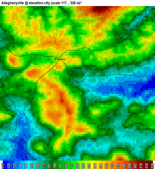
Below is the Elevation map of Alleghenyville, which displays elevation range with different colors. Scale of the first map is from 117 to 326 m (384 to 1070 ft) with average elevation of 201.8 meters (=662 ft) [note 1]
These maps also provides idea of topography and contour of this city, they are displayed at different zoom levels. More info about maps, scale and edge coordinates you can find below images.
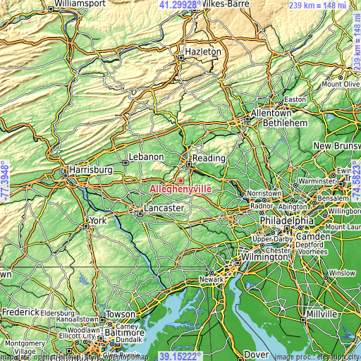
| \ | Map #1 | Topo.Map |
| Scale [m] | 117..326 m | × |
| Scale [ft] | 384..1070 ft | × |
| Average | 201.8 m = 662 ft | × |
| Width | 7.46 km = 4.6 mi | 238.7 km = 148.3 mi |
| Height | 7.46 km = 4.6 mi | 238.7 km = 148.3 mi |
| ↑Max Latitude | 40.2678° | 41.29928° |
| Latitude at center | 40.23426° | 40.23426° |
| ↓Min Latitude | 40.200703° | 39.15222° |
| ← Min Longitude | -76.032495° | -77.3948° |
| Longitude center | -75.98855° | -75.98855° |
| →Max Longitude | -75.944605° | -74.5823° |
Nearby cities:
Cities around Alleghenyville sort by population:
• Shillington elevation 102 m
8.4 km,  13°
13°
• Mohnton 154 m
5.8 km,  3°
3°
• Kenhorst 106 m
9.5 km,  26°
26°
• Flying Hills 126 m
7.9 km,  53°
53°
• Swartzville 173 m
7.6 km,  269°
269°
• Bowmansville 133 m
4.8 km,  210°
210°
• Adamstown 146 m
5.8 km,  277°
277°
• Lincoln Park 93 m
9 km, 1°
• Montrose 113 m
8 km, 0°
• Grill 97 m
8.2 km, 29°
• Terre Hill 165 m
10 km, 211°
• Fivepointville 137 m
7.8 km,  222°
222°
Multilingual:
 En español:
Alleghenyville elevación 171 m.
 En France:
Alleghenyville élévation 171 m.
 Auf Deutsch:
Alleghenyville höhe über dem Meeresspiegel ist 171 m.

Sources and notes:
- [note 1] Map square and city borders are not equal. Map elevation data is calculated only from area inside that square.
- [src 1] Elevation data from geonames database provided with same terms of usage.
- [src 2] The elevation map of Alleghenyville is generated using elevation data from NASA's 3 arcsec (90m) resolution SRTM data.
- [src 3] Base (background) map © OpenStreetMap contributors tiles are generated by Geofabrik and OpenTopoMap.
Copyright & License:
This Alleghenyville Elevation Map is licensed under CC BY-SA. You may reuse any part from this page, if you give a proper credit by linking to this URL:
 More info on terms of use page.