Bloomfield elevation
Bloomfield (Pennsylvania, Allegheny County), United States elevation is 289 meters and Bloomfield elevation in feet is 948 ft above sea level [src 1]. Bloomfield is a populated place (feature code) with elevation that is 10 meters (33 ft) bigger than average city elevation in United States.
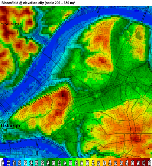
Below is the Elevation map of Bloomfield, which displays elevation range with different colors. Scale of the first map is from 209 to 380 m (686 to 1247 ft) with average elevation of 280.7 meters (=921 ft) [note 1]
These maps also provides idea of topography and contour of this city, they are displayed at different zoom levels. More info about maps, scale and edge coordinates you can find below images.
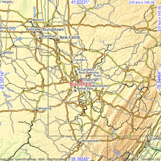
| \ | Map #1 | Topo.Map |
| Scale [m] | 209..380 m | × |
| Scale [ft] | 686..1247 ft | × |
| Average | 280.7 m = 921 ft | × |
| Width | 7.44 km = 4.6 mi | 237.9 km = 147.8 mi |
| Height | 7.44 km = 4.6 mi | 237.9 km = 147.8 mi |
| ↑Max Latitude | 40.494327° | 41.52231° |
| Latitude at center | 40.4609° | 40.4609° |
| ↓Min Latitude | 40.427456° | 39.38245° |
| ← Min Longitude | -79.994835° | -81.35714° |
| Longitude center | -79.95089° | -79.95089° |
| →Max Longitude | -79.906945° | -78.54464° |
Nearby cities:
Cities around Bloomfield sort by population:
• Pittsburgh elevation 239 m
4.4 km,  239°
239°
• Wilkinsburg 288 m
6.2 km,  110°
110°
• Swissvale 321 m
7.1 km,  125°
125°
• Millvale 244 m
3.2 km,  312°
312°
• Etna 225 m
4.8 km,  1°
1°
• Sharpsburg 226 m
4.3 km,  28°
28°
• Mount Oliver 351 m
6.1 km,  211°
211°
• Homestead 242 m
6.9 km,  151°
151°
• Edgewood 299 m
6.7 km,  118°
118°
• Aspinwall 228 m
5.2 km,  48°
48°
• Rankin 266 m
8.1 km, 131°
• West Homestead 310 m
8.1 km,  156°
156°
Multilingual:
 En español:
Bloomfield elevación 289 m.
 En France:
Bloomfield élévation 289 m.
 Auf Deutsch:
Bloomfield höhe über dem Meeresspiegel ist 289 m.

Sources and notes:
- [note 1] Map square and city borders are not equal. Map elevation data is calculated only from area inside that square.
- [src 1] Elevation data from geonames database provided with same terms of usage.
- [src 2] The elevation map of Bloomfield is generated using elevation data from NASA's 3 arcsec (90m) resolution SRTM data.
- [src 3] Base (background) map © OpenStreetMap contributors tiles are generated by Geofabrik and OpenTopoMap.
Copyright & License:
This Bloomfield Elevation Map is licensed under CC BY-SA. You may reuse any part from this page, if you give a proper credit by linking to this URL:
 More info on terms of use page.