Aspinwall elevation
Aspinwall (Pennsylvania, Allegheny County), United States elevation is 228 meters and Aspinwall elevation in feet is 748 ft above sea level [src 1]. Aspinwall is a populated place (feature code) with elevation that is 51 meters (167 ft) smaller than average city elevation in United States.
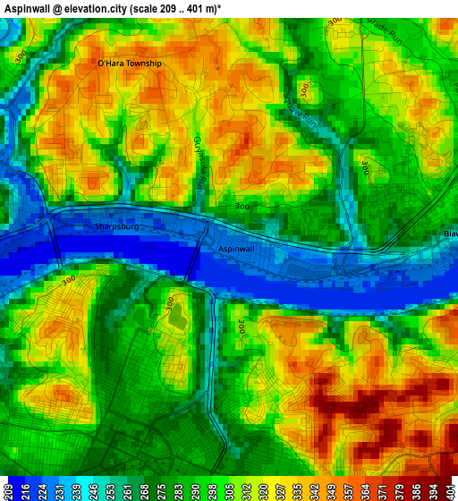
Below is the Elevation map of Aspinwall, which displays elevation range with different colors. Scale of the first map is from 209 to 401 m (686 to 1316 ft) with average elevation of 296 meters (=971 ft) [note 1]
These maps also provides idea of topography and contour of this city, they are displayed at different zoom levels. More info about maps, scale and edge coordinates you can find below images.
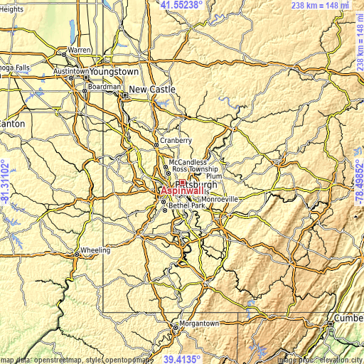
| \ | Map #1 | Topo.Map |
| Scale [m] | 209..401 m | × |
| Scale [ft] | 686..1316 ft | × |
| Average | 296 m = 971 ft | × |
| Width | 7.43 km = 4.6 mi | 237.8 km = 147.8 mi |
| Height | 7.43 km = 4.6 mi | 237.8 km = 147.8 mi |
| ↑Max Latitude | 40.524872° | 41.55238° |
| Latitude at center | 40.49146° | 40.49146° |
| ↓Min Latitude | 40.458031° | 39.4135° |
| ← Min Longitude | -79.948715° | -81.31102° |
| Longitude center | -79.90477° | -79.90477° |
| →Max Longitude | -79.860825° | -78.49852° |
Nearby cities:
Cities around Aspinwall sort by population:
• Penn Hills elevation 283 m
5.6 km,  78°
78°
• Wilkinsburg 288 m
5.9 km,  160°
160°
• Glenshaw 334 m
7 km,  310°
310°
• Oakmont 234 m
6.3 km,  57°
57°
• Fox Chapel 302 m
3.2 km,  40°
40°
• Millvale 244 m
6.4 km,  258°
258°
• Etna 225 m
4 km,  290°
290°
• Sharpsburg 226 m
1.9 km,  280°
280°
• Edgewood 299 m
6.9 km, 163°
• Verona 228 m
5.5 km,  72°
72°
• Blawnox 246 m
3.7 km,  86°
86°
• Bloomfield 289 m
5.2 km,  228°
228°
Multilingual:
 En español:
Aspinwall elevación 228 m.
 En France:
Aspinwall élévation 228 m.
 Auf Deutsch:
Aspinwall höhe über dem Meeresspiegel ist 228 m.

Sources and notes:
- [note 1] Map square and city borders are not equal. Map elevation data is calculated only from area inside that square.
- [src 1] Elevation data from geonames database provided with same terms of usage.
- [src 2] The elevation map of Aspinwall is generated using elevation data from NASA's 3 arcsec (90m) resolution SRTM data.
- [src 3] Base (background) map © OpenStreetMap contributors tiles are generated by Geofabrik and OpenTopoMap.
Copyright & License:
This Aspinwall Elevation Map is licensed under CC BY-SA. You may reuse any part from this page, if you give a proper credit by linking to this URL:
 More info on terms of use page.