Mount Vernon elevation
Mount Vernon (Ohio, Knox County), United States elevation is 311 meters and Mount Vernon elevation in feet is 1020 ft above sea level [src 1]. Mount Vernon is a seat of a second-order administrative division (feature code) with elevation that is 32 meters (105 ft) bigger than average city elevation in United States.
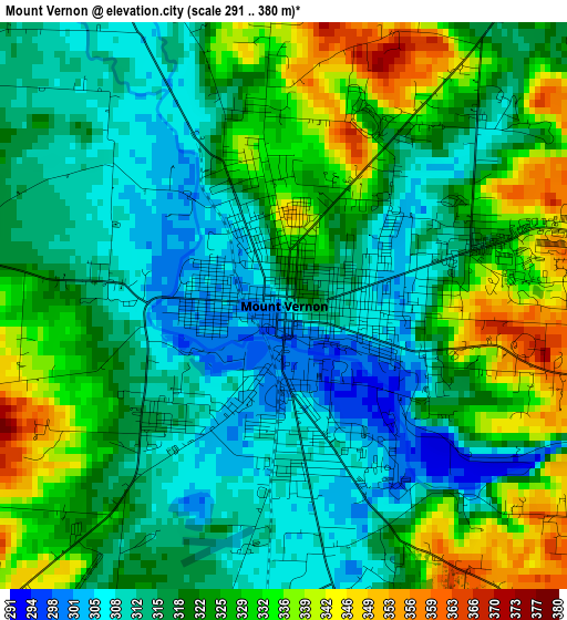
Below is the Elevation map of Mount Vernon, which displays elevation range with different colors. Scale of the first map is from 291 to 380 m (955 to 1247 ft) with average elevation of 321.1 meters (=1053 ft) [note 1]
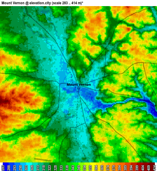
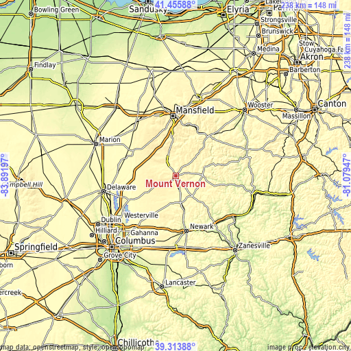
These maps also provides idea of topography and contour of this city, they are displayed at different zoom levels. More info about maps, scale and edge coordinates you can find below images.
| \ | Map #1 | Map #2 | Topo.Map |
| Scale [m] | 291..380 m | 283..414 m | × |
| Scale [ft] | 955..1247 ft | 928..1358 ft | × |
| Average | 321.1 m = 1053 ft | 338.5 m = 1111 ft | × |
| Width | 7.44 km = 4.6 mi | 14.89 km = 9.3 mi | 238.2 km = 148 mi |
| Height | 7.44 km = 4.6 mi | 14.89 km = 9.3 mi | 238.2 km = 148 mi |
| ↑Max Latitude | 40.426861° | 40.460305° | 41.45588° |
| Latitude at center | 40.3934° | 40.3934° | 40.3934° |
| ↓Min Latitude | 40.359922° | 40.326428° | 39.31388° |
| ← Min Longitude | -82.529665° | -82.573611° | -83.89197° |
| Longitude center | -82.48572° | -82.48572° | -82.48572° |
| →Max Longitude | -82.441775° | -82.397829° | -81.07947° |
Nearby cities:
Cities around Mount Vernon sort by population:
• Apple Valley elevation 344 m
12.3 km,  65°
65°
• Johnstown 354 m
31.6 km,  212°
212°
• Lexington 371 m
32.8 km,  345°
345°
• Mount Gilead 348 m
33.7 km,  300°
300°
• Loudonville 297 m
34.3 km,  38°
38°
• Fredericktown 340 m
10.8 km,  334°
334°
• Gambier 333 m
7.8 km,  104°
104°
• Utica 295 m
17.9 km,  170°
170°
• Centerburg 374 m
20.4 km,  241°
241°
• Bellville 348 m
25.3 km,  355°
355°
• Oak Hill 293 m
20.9 km,  83°
83°
• Danville 302 m
20 km, 72°
Multilingual:
 En español:
Mount Vernon elevación 311 m.
 En France:
Mount Vernon élévation 311 m.
 Auf Deutsch:
Mount Vernon höhe über dem Meeresspiegel ist 311 m.

Sources and notes:
- [note 1] Map square and city borders are not equal. Map elevation data is calculated only from area inside that square.
- [src 1] Elevation data from geonames database provided with same terms of usage.
- [src 2] The elevation map of Mount Vernon is generated using elevation data from NASA's 3 arcsec (90m) resolution SRTM data.
- [src 3] Base (background) map © OpenStreetMap contributors tiles are generated by Geofabrik and OpenTopoMap.
Copyright & License:
This Mount Vernon Elevation Map is licensed under CC BY-SA. You may reuse any part from this page, if you give a proper credit by linking to this URL:
 More info on terms of use page.