Montpelier elevation
Montpelier (Ohio, Williams County), United States elevation is 266 meters and Montpelier elevation in feet is 873 ft above sea level [src 1]. Montpelier is a populated place (feature code) with elevation that is 13 meters (43 ft) smaller than average city elevation in United States.
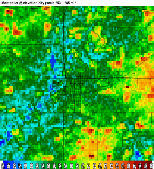
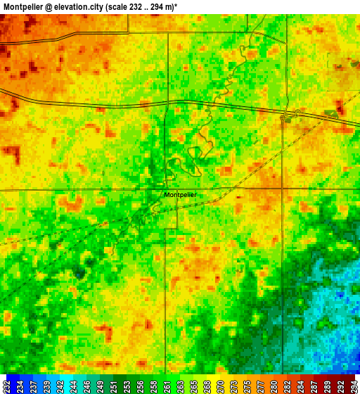
Below is the Elevation map of Montpelier, which displays elevation range with different colors. Scale of the first map is from 253 to 285 m (830 to 935 ft) with average elevation of 265.6 meters (=871 ft) [note 1]
These maps also provides idea of topography and contour of this city, they are displayed at different zoom levels. More info about maps, scale and edge coordinates you can find below images.
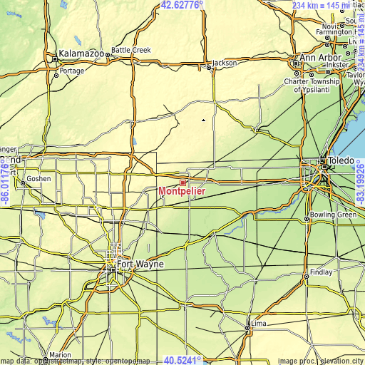
| \ | Map #1 | Map #2 | Topo.Map |
| Scale [m] | 253..285 m | 232..294 m | × |
| Scale [ft] | 830..935 ft | 761..965 ft | × |
| Average | 265.6 m = 871 ft | 265 m = 869 ft | × |
| Width | 7.31 km = 4.5 mi | 14.62 km = 9.1 mi | 233.9 km = 145.3 mi |
| Height | 7.31 km = 4.5 mi | 14.62 km = 9.1 mi | 233.9 km = 145.3 mi |
| ↑Max Latitude | 41.617362° | 41.650207° | 42.62776° |
| Latitude at center | 41.5845° | 41.5845° | 41.5845° |
| ↓Min Latitude | 41.551622° | 41.518726° | 40.5241° |
| ← Min Longitude | -84.649455° | -84.693401° | -86.01176° |
| Longitude center | -84.60551° | -84.60551° | -84.60551° |
| →Max Longitude | -84.561565° | -84.517619° | -83.19926° |
Nearby cities:
Cities around Montpelier sort by population:
• Bryan elevation 234 m
13 km,  160°
160°
• Archbold 223 m
25.8 km,  105°
105°
• Butler 266 m
28 km,  232°
232°
• Burlington 217 m
24.8 km,  93°
93°
• Fremont 321 m
31.7 km,  300°
300°
• Edgerton 259 m
19.2 km,  218°
218°
• West Unity 241 m
14.2 km, 89°
• Hamilton 276 m
26.2 km,  257°
257°
• Pioneer 269 m
11.5 km,  22°
22°
• Stryker 217 m
18.3 km,  119°
119°
• Fayette 240 m
25.2 km,  66°
66°
• Reading 366 m
30.7 km,  337°
337°
Multilingual:
 En español:
Montpelier elevación 266 m.
 En France:
Montpelier élévation 266 m.
 Auf Deutsch:
Montpelier höhe über dem Meeresspiegel ist 266 m.

Sources and notes:
- [note 1] Map square and city borders are not equal. Map elevation data is calculated only from area inside that square.
- [src 1] Elevation data from geonames database provided with same terms of usage.
- [src 2] The elevation map of Montpelier is generated using elevation data from NASA's 3 arcsec (90m) resolution SRTM data.
- [src 3] Base (background) map © OpenStreetMap contributors tiles are generated by Geofabrik and OpenTopoMap.
Copyright & License:
This Montpelier Elevation Map is licensed under CC BY-SA. You may reuse any part from this page, if you give a proper credit by linking to this URL:
 More info on terms of use page.