Fremont elevation
Fremont (Indiana, Steuben County), United States elevation is 321 meters and Fremont elevation in feet is 1053 ft above sea level [src 1]. Fremont is a populated place (feature code) with elevation that is 42 meters (138 ft) bigger than average city elevation in United States.
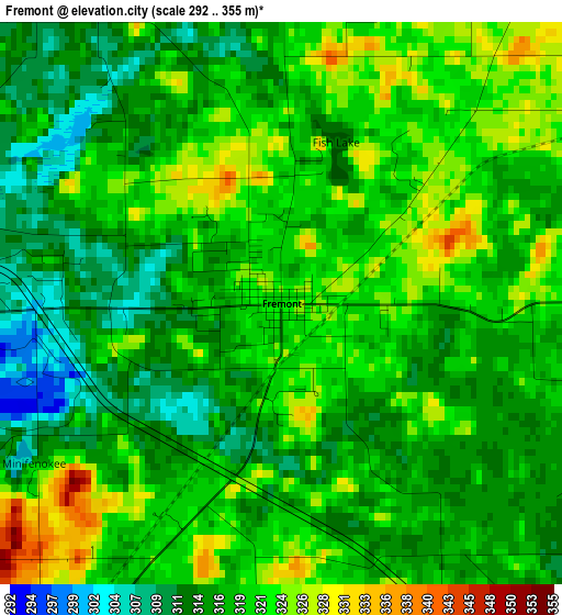
Below is the Elevation map of Fremont, which displays elevation range with different colors. Scale of the first map is from 292 to 355 m (958 to 1165 ft) with average elevation of 318.2 meters (=1044 ft) [note 1]
These maps also provides idea of topography and contour of this city, they are displayed at different zoom levels. More info about maps, scale and edge coordinates you can find below images.
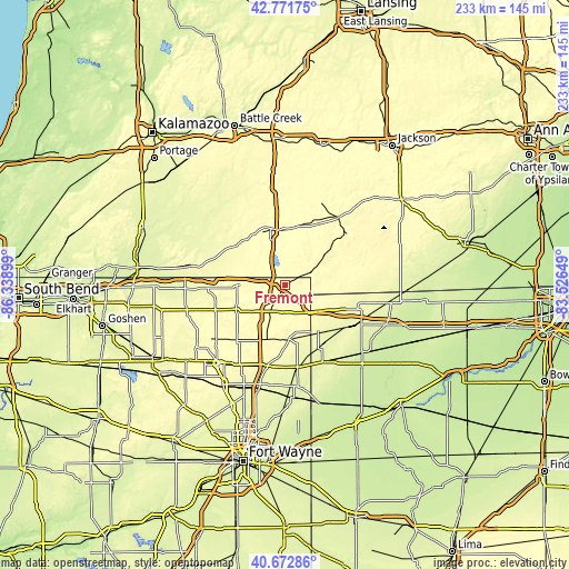
| \ | Map #1 | Topo.Map |
| Scale [m] | 292..355 m | × |
| Scale [ft] | 958..1165 ft | × |
| Average | 318.2 m = 1044 ft | × |
| Width | 7.29 km = 4.5 mi | 233.4 km = 145 mi |
| Height | 7.29 km = 4.5 mi | 233.4 km = 145 mi |
| ↑Max Latitude | 41.763667° | 42.77175° |
| Latitude at center | 41.73088° | 41.73088° |
| ↓Min Latitude | 41.698076° | 40.67286° |
| ← Min Longitude | -84.976685° | -86.33899° |
| Longitude center | -84.93274° | -84.93274° |
| →Max Longitude | -84.888795° | -83.52649° |
Nearby cities:
Cities around Fremont sort by population:
• Coldwater elevation 296 m
24 km,  346°
346°
• Angola 324 m
12 km,  207°
207°
• Hillsdale 345 m
32.7 km,  49°
49°
• Montpelier 266 m
31.7 km,  120°
120°
• Butler 266 m
33.9 km,  171°
171°
• Bronson 281 m
26.8 km,  305°
305°
• Waterloo 278 m
34 km,  192°
192°
• Edgerton 259 m
34.9 km,  153°
153°
• Quincy 313 m
24.1 km,  9°
9°
• Hamilton 276 m
22 km,  175°
175°
• Pioneer 269 m
32 km,  100°
100°
• Reading 366 m
19.5 km, 51°
Multilingual:
 En español:
Fremont elevación 321 m.
 En France:
Fremont élévation 321 m.


Sources and notes:
- [note 1] Map square and city borders are not equal. Map elevation data is calculated only from area inside that square.
- [src 1] Elevation data from geonames database provided with same terms of usage.
- [src 2] The elevation map of Fremont is generated using elevation data from NASA's 3 arcsec (90m) resolution SRTM data.
- [src 3] Base (background) map © OpenStreetMap contributors tiles are generated by Geofabrik and OpenTopoMap.
Copyright & License:
This Fremont Elevation Map is licensed under CC BY-SA. You may reuse any part from this page, if you give a proper credit by linking to this URL:
 More info on terms of use page.