Wallkill elevation
Wallkill (New York, Ulster County), United States elevation is 88 meters and Wallkill elevation in feet is 289 ft above sea level [src 1]. Wallkill is a populated place (feature code) with elevation that is 191 meters (627 ft) smaller than average city elevation in United States.
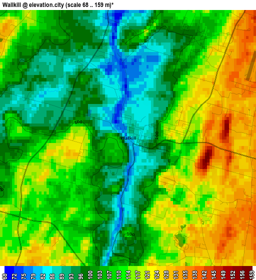
Below is the Elevation map of Wallkill, which displays elevation range with different colors. Scale of the first map is from 68 to 159 m (223 to 522 ft) with average elevation of 108 meters (=354 ft) [note 1]
These maps also provides idea of topography and contour of this city, they are displayed at different zoom levels. More info about maps, scale and edge coordinates you can find below images.
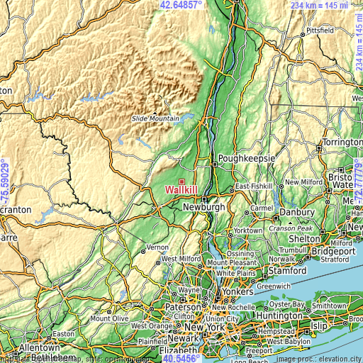
| \ | Map #1 | Topo.Map |
| Scale [m] | 68..159 m | × |
| Scale [ft] | 223..522 ft | × |
| Average | 108 m = 354 ft | × |
| Width | 7.31 km = 4.5 mi | 233.8 km = 145.3 mi |
| Height | 7.31 km = 4.5 mi | 233.8 km = 145.3 mi |
| ↑Max Latitude | 41.638501° | 42.64857° |
| Latitude at center | 41.60565° | 41.60565° |
| ↓Min Latitude | 41.572782° | 40.5456° |
| ← Min Longitude | -74.227985° | -75.59029° |
| Longitude center | -74.18404° | -74.18404° |
| →Max Longitude | -74.140095° | -72.77779° |
Nearby cities:
Cities around Wallkill sort by population:
• New Paltz elevation 76 m
17.7 km,  27°
27°
• Orange Lake 152 m
10.2 km,  135°
135°
• Walden 114 m
5 km,  184°
184°
• Montgomery 117 m
9.7 km,  206°
206°
• Gardnertown 132 m
12.3 km,  129°
129°
• Marlboro 59 m
17.7 km,  90°
90°
• Maybrook 131 m
13.8 km,  191°
191°
• Balmville 74 m
16.1 km,  119°
119°
• Watchtower 109 m
7.3 km,  299°
299°
• Pine Bush 121 m
9.6 km,  271°
271°
• Clintondale 170 m
14.8 km,  48°
48°
• Plattekill 176 m
9.1 km,  81°
81°
Multilingual:
 En español:
Wallkill elevación 88 m.
 En France:
Wallkill élévation 88 m.


Sources and notes:
- [note 1] Map square and city borders are not equal. Map elevation data is calculated only from area inside that square.
- [src 1] Elevation data from geonames database provided with same terms of usage.
- [src 2] The elevation map of Wallkill is generated using elevation data from NASA's 3 arcsec (90m) resolution SRTM data.
- [src 3] Base (background) map © OpenStreetMap contributors tiles are generated by Geofabrik and OpenTopoMap.
Copyright & License:
This Wallkill Elevation Map is licensed under CC BY-SA. You may reuse any part from this page, if you give a proper credit by linking to this URL:
 More info on terms of use page.