Marlboro elevation
Marlboro (New York, Ulster County), United States elevation is 59 meters and Marlboro elevation in feet is 194 ft above sea level [src 1]. Marlboro is a populated place (feature code) with elevation that is 220 meters (722 ft) smaller than average city elevation in United States.
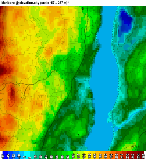
Below is the Elevation map of Marlboro, which displays elevation range with different colors. Scale of the first map is from -57 to 267 m (-187 to 876 ft) with average elevation of 84 meters (=276 ft) [note 1]
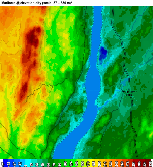
These maps also provides idea of topography and contour of this city, they are displayed at different zoom levels. More info about maps, scale and edge coordinates you can find below images.
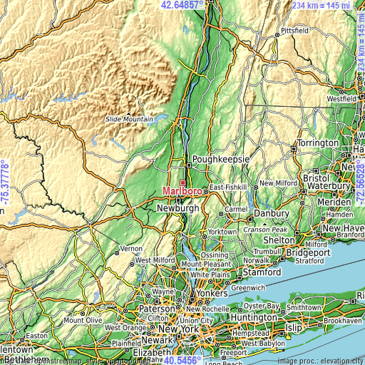
| \ | Map #1 | Map #2 | Topo.Map |
| Scale [m] | -57..267 m | -57..336 m | × |
| Scale [ft] | -187..876 ft | -187..1102 ft | × |
| Average | 84 m = 276 ft | 107.3 m = 352 ft | × |
| Width | 7.31 km = 4.5 mi | 14.61 km = 9.1 mi | 233.8 km = 145.3 mi |
| Height | 7.31 km = 4.5 mi | 14.61 km = 9.1 mi | 233.8 km = 145.3 mi |
| ↑Max Latitude | 41.638501° | 41.671335° | 42.64857° |
| Latitude at center | 41.60565° | 41.60565° | 41.60565° |
| ↓Min Latitude | 41.572782° | 41.539898° | 40.5456° |
| ← Min Longitude | -74.015475° | -74.059421° | -75.37778° |
| Longitude center | -73.97153° | -73.97153° | -73.97153° |
| →Max Longitude | -73.927585° | -73.883639° | -72.56528° |
Nearby cities:
Cities around Marlboro sort by population:
• Beacon elevation 44 m
11.2 km,  179°
179°
• Myers Corner 66 m
8.2 km,  89°
89°
• Wappingers Falls 50 m
5.1 km,  101°
101°
• Spackenkill 50 m
7.4 km,  40°
40°
• Red Oaks Mill 52 m
9.8 km,  55°
55°
• Balmville 74 m
8.7 km,  204°
204°
• Brinckerhoff 71 m
11 km,  128°
128°
• Crown Heights 42 m
4.5 km, 38°
• Fishkill 71 m
9.8 km,  142°
142°
• Milton 48 m
6.1 km,  11°
11°
• Plattekill 176 m
8.8 km,  278°
278°
• Merritt Park 92 m
11.1 km, 132°
Multilingual:
 En español:
Marlboro elevación 59 m.
 En France:
Marlboro élévation 59 m.


Sources and notes:
- [note 1] Map square and city borders are not equal. Map elevation data is calculated only from area inside that square.
- [src 1] Elevation data from geonames database provided with same terms of usage.
- [src 2] The elevation map of Marlboro is generated using elevation data from NASA's 3 arcsec (90m) resolution SRTM data.
- [src 3] Base (background) map © OpenStreetMap contributors tiles are generated by Geofabrik and OpenTopoMap.
Copyright & License:
This Marlboro Elevation Map is licensed under CC BY-SA. You may reuse any part from this page, if you give a proper credit by linking to this URL:
 More info on terms of use page.