Spackenkill elevation
Spackenkill (New York, Dutchess County), United States elevation is 50 meters and Spackenkill elevation in feet is 164 ft above sea level [src 1]. Spackenkill is a populated place (feature code) with elevation that is 229 meters (751 ft) smaller than average city elevation in United States.
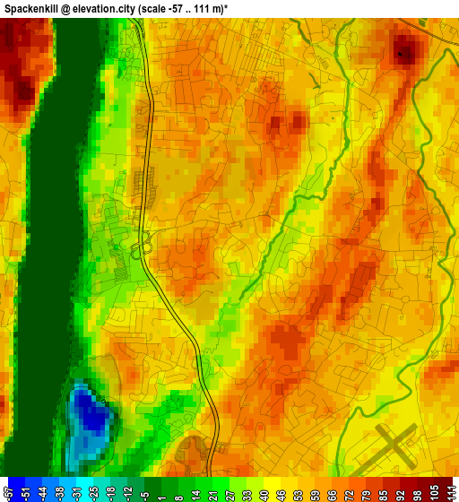
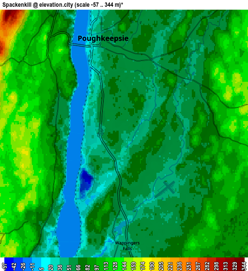
Below is the Elevation map of Spackenkill, which displays elevation range with different colors. Scale of the first map is from -57 to 111 m (-187 to 364 ft) with average elevation of 46 meters (=151 ft) [note 1]
These maps also provides idea of topography and contour of this city, they are displayed at different zoom levels. More info about maps, scale and edge coordinates you can find below images.
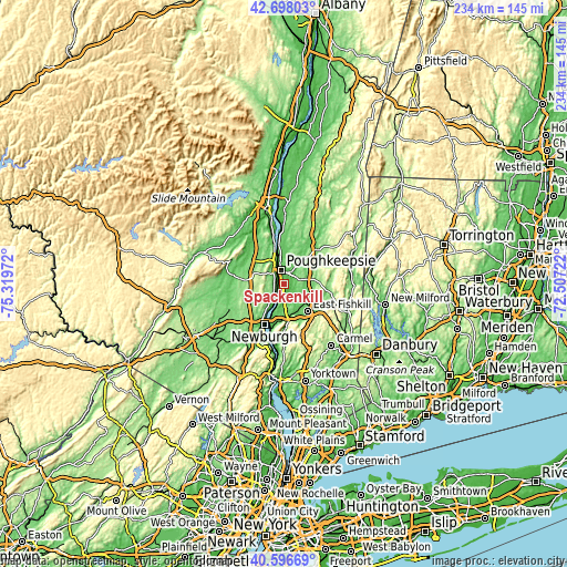
| \ | Map #1 | Map #2 | Topo.Map |
| Scale [m] | -57..111 m | -57..344 m | × |
| Scale [ft] | -187..364 ft | -187..1129 ft | × |
| Average | 46 m = 151 ft | 77.4 m = 254 ft | × |
| Width | 7.3 km = 4.5 mi | 14.6 km = 9.1 mi | 233.6 km = 145.2 mi |
| Height | 7.3 km = 4.5 mi | 14.6 km = 9.1 mi | 233.6 km = 145.2 mi |
| ↑Max Latitude | 41.688755° | 41.721564° | 42.69803° |
| Latitude at center | 41.65593° | 41.65593° | 41.65593° |
| ↓Min Latitude | 41.623088° | 41.590229° | 40.59669° |
| ← Min Longitude | -73.957415° | -74.001361° | -75.31972° |
| Longitude center | -73.91347° | -73.91347° | -73.91347° |
| →Max Longitude | -73.869525° | -73.825579° | -72.50722° |
Nearby cities:
Cities around Spackenkill sort by population:
• Poughkeepsie elevation 61 m
5 km,  352°
352°
• Myers Corner 66 m
6.5 km,  148°
148°
• Highland 53 m
8.2 km,  331°
331°
• Wappingers Falls 50 m
6.6 km,  178°
178°
• Fairview 70 m
7.6 km,  355°
355°
• Arlington 55 m
4.7 km,  17°
17°
• Marlboro 59 m
7.4 km,  220°
220°
• Red Oaks Mill 52 m
3.2 km,  90°
90°
• Crown Heights 42 m
2.9 km, 224°
• Clintondale 170 m
12.2 km,  290°
290°
• Milton 48 m
3.6 km,  276°
276°
• Hillside Lake 114 m
10.6 km,  115°
115°
Multilingual:
 En español:
Spackenkill elevación 50 m.
 En France:
Spackenkill élévation 50 m.
 Auf Deutsch:
Spackenkill höhe über dem Meeresspiegel ist 50 m.

Sources and notes:
- [note 1] Map square and city borders are not equal. Map elevation data is calculated only from area inside that square.
- [src 1] Elevation data from geonames database provided with same terms of usage.
- [src 2] The elevation map of Spackenkill is generated using elevation data from NASA's 3 arcsec (90m) resolution SRTM data.
- [src 3] Base (background) map © OpenStreetMap contributors tiles are generated by Geofabrik and OpenTopoMap.
Copyright & License:
This Spackenkill Elevation Map is licensed under CC BY-SA. You may reuse any part from this page, if you give a proper credit by linking to this URL:
 More info on terms of use page.