Upper Nyack elevation
Upper Nyack (New York, Rockland County), United States elevation is 62 meters and Upper Nyack elevation in feet is 203 ft above sea level [src 1]. Upper Nyack is a populated place (feature code) with elevation that is 217 meters (712 ft) smaller than average city elevation in United States.
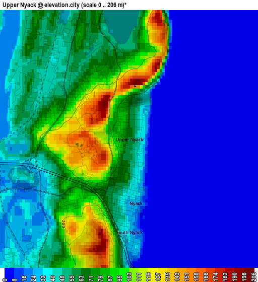
Below is the Elevation map of Upper Nyack, which displays elevation range with different colors. Scale of the first map is from 0 to 206 m (0 to 676 ft) with average elevation of 43 meters (=141 ft) [note 1]
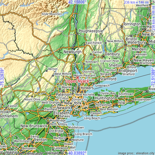
These maps also provides idea of topography and contour of this city, they are displayed at different zoom levels. More info about maps, scale and edge coordinates you can find below images.
| \ | Map #1 | Topo.Map |
| Scale [m] | 0..206 m | × |
| Scale [ft] | 0..676 ft | × |
| Average | 43 m = 141 ft | × |
| Width | 7.36 km = 4.6 mi | 235.6 km = 146.4 mi |
| Height | 7.36 km = 4.6 mi | 235.6 km = 146.4 mi |
| ↑Max Latitude | 41.140144° | 42.15806° |
| Latitude at center | 41.10704° | 41.10704° |
| ↓Min Latitude | 41.07392° | 40.03892° |
| ← Min Longitude | -73.964085° | -75.32639° |
| Longitude center | -73.92014° | -73.92014° |
| →Max Longitude | -73.876195° | -72.51389° |
Nearby cities:
Cities around Upper Nyack sort by population:
• New City elevation 53 m
7.3 km,  307°
307°
• Tarrytown 45 m
6.2 km,  123°
123°
• Sleepy Hollow 34 m
5.7 km,  114°
114°
• Valley Cottage 61 m
3.2 km,  292°
292°
• Congers 64 m
5.3 km,  336°
336°
• Nyack 26 m
1.8 km,  174°
174°
• Blauvelt 66 m
5.8 km,  212°
212°
• Orangeburg 38 m
7.2 km,  200°
200°
• Bardonia 96 m
6.4 km,  272°
272°
• South Nyack 29 m
2.7 km,  180°
180°
• West Nyack 27 m
4.6 km,  255°
255°
• Piermont 46 m
7.2 km, 178°
Multilingual:
 En español:
Upper Nyack elevación 62 m.
 En France:
Upper Nyack élévation 62 m.
 Auf Deutsch:
Upper Nyack höhe über dem Meeresspiegel ist 62 m.

Sources and notes:
- [note 1] Map square and city borders are not equal. Map elevation data is calculated only from area inside that square.
- [src 1] Elevation data from geonames database provided with same terms of usage.
- [src 2] The elevation map of Upper Nyack is generated using elevation data from NASA's 3 arcsec (90m) resolution SRTM data.
- [src 3] Base (background) map © OpenStreetMap contributors tiles are generated by Geofabrik and OpenTopoMap.
Copyright & License:
This Upper Nyack Elevation Map is licensed under CC BY-SA. You may reuse any part from this page, if you give a proper credit by linking to this URL:
 More info on terms of use page.