Port Jervis elevation
Port Jervis (New York, Orange County), United States elevation is 134 meters and Port Jervis elevation in feet is 440 ft above sea level [src 1]. Port Jervis is a populated place (feature code) with elevation that is 145 meters (476 ft) smaller than average city elevation in United States.
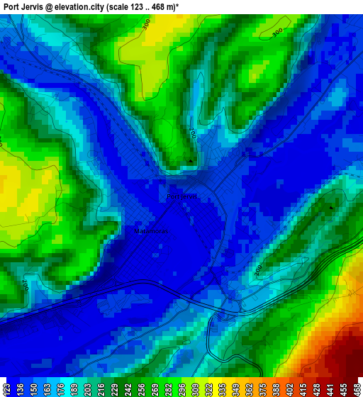
Below is the Elevation map of Port Jervis, which displays elevation range with different colors. Scale of the first map is from 123 to 468 m (404 to 1535 ft) with average elevation of 203 meters (=666 ft) [note 1]
These maps also provides idea of topography and contour of this city, they are displayed at different zoom levels. More info about maps, scale and edge coordinates you can find below images.
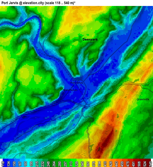
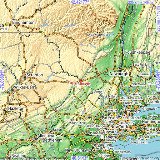
| \ | Map #1 | Map #2 | Topo.Map |
| Scale [m] | 123..468 m | 118..540 m | × |
| Scale [ft] | 404..1535 ft | 387..1772 ft | × |
| Average | 203 m = 666 ft | 261.7 m = 859 ft | × |
| Width | 7.33 km = 4.6 mi | 14.67 km = 9.1 mi | 234.7 km = 145.8 mi |
| Height | 7.33 km = 4.6 mi | 14.67 km = 9.1 mi | 234.7 km = 145.8 mi |
| ↑Max Latitude | 41.408058° | 41.44101° | 42.42177° |
| Latitude at center | 41.37509° | 41.37509° | 41.37509° |
| ↓Min Latitude | 41.342105° | 41.309104° | 40.3113° |
| ← Min Longitude | -74.736605° | -74.780551° | -76.09891° |
| Longitude center | -74.69266° | -74.69266° | -74.69266° |
| →Max Longitude | -74.648715° | -74.604769° | -73.28641° |
Nearby cities:
Cities around Port Jervis sort by population:
• Middletown elevation 171 m
23.8 km,  70°
70°
• Eden 122 m
19.1 km,  120°
120°
• Matamoras 134 m
0.9 km,  221°
221°
• Sussex 138 m
19.7 km,  158°
158°
• Gold Key Lake 424 m
21.9 km,  249°
249°
• Vernon Center 204 m
26 km,  142°
142°
• Washington Heights 212 m
25.4 km, 65°
• Vernon Valley 198 m
23.1 km,  131°
131°
• Sunrise Lake 449 m
24 km, 252°
• Birchwood Lakes 354 m
23.1 km,  234°
234°
• Otisville 266 m
16.9 km,  49°
49°
• Milford 154 m
10.9 km,  237°
237°
Multilingual:
 En español:
Port Jervis elevación 134 m.
 En France:
Port Jervis élévation 134 m.
 Auf Deutsch:
Port Jervis höhe über dem Meeresspiegel ist 134 m.

Sources and notes:
- [note 1] Map square and city borders are not equal. Map elevation data is calculated only from area inside that square.
- [src 1] Elevation data from geonames database provided with same terms of usage.
- [src 2] The elevation map of Port Jervis is generated using elevation data from NASA's 3 arcsec (90m) resolution SRTM data.
- [src 3] Base (background) map © OpenStreetMap contributors tiles are generated by Geofabrik and OpenTopoMap.
Copyright & License:
This Port Jervis Elevation Map is licensed under CC BY-SA. You may reuse any part from this page, if you give a proper credit by linking to this URL:
 More info on terms of use page.