Washington Heights elevation
Washington Heights (New York, Orange County), United States elevation is 212 meters and Washington Heights elevation in feet is 696 ft above sea level [src 1]. Washington Heights is a populated place (feature code) with elevation that is 67 meters (220 ft) smaller than average city elevation in United States.
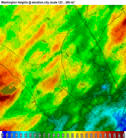
Below is the Elevation map of Washington Heights, which displays elevation range with different colors. Scale of the first map is from 123 to 266 m (404 to 873 ft) with average elevation of 194.2 meters (=637 ft) [note 1]
These maps also provides idea of topography and contour of this city, they are displayed at different zoom levels. More info about maps, scale and edge coordinates you can find below images.
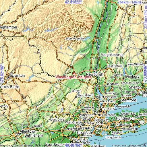
| \ | Map #1 | Topo.Map |
| Scale [m] | 123..266 m | × |
| Scale [ft] | 404..873 ft | × |
| Average | 194.2 m = 637 ft | × |
| Width | 7.32 km = 4.5 mi | 234.3 km = 145.6 mi |
| Height | 7.32 km = 4.5 mi | 234.3 km = 145.6 mi |
| ↑Max Latitude | 41.50301° | 42.51522° |
| Latitude at center | 41.47009° | 41.47009° |
| ↓Min Latitude | 41.437153° | 40.40784° |
| ← Min Longitude | -74.459655° | -75.82196° |
| Longitude center | -74.41571° | -74.41571° |
| →Max Longitude | -74.371765° | -73.00946° |
Nearby cities:
Cities around Washington Heights sort by population:
• Middletown elevation 171 m
2.8 km,  192°
192°
• Scotchtown 224 m
4.8 km,  74°
74°
• Mechanicstown 169 m
3.8 km,  143°
143°
• Goshen 133 m
10.7 km,  134°
134°
• Montgomery 117 m
16.2 km, 66°
• Chester 145 m
17 km, 134°
• Eden 122 m
21.2 km,  198°
198°
• Maybrook 131 m
16.6 km,  84°
84°
• Florida 139 m
16.1 km,  162°
162°
• Pine Bush 121 m
18.2 km,  32°
32°
• Wurtsboro 177 m
13.3 km,  333°
333°
• Otisville 266 m
10.2 km,  272°
272°
Multilingual:
 En español:
Washington Heights elevación 212 m.
 En France:
Washington Heights élévation 212 m.
 Auf Deutsch:
Washington Heights höhe über dem Meeresspiegel ist 212 m.
 На русском:
Washington Heights высота над уровнем моря 212 м
Sources and notes:
- [note 1] Map square and city borders are not equal. Map elevation data is calculated only from area inside that square.
- [src 1] Elevation data from geonames database provided with same terms of usage.
- [src 2] The elevation map of Washington Heights is generated using elevation data from NASA's 3 arcsec (90m) resolution SRTM data.
- [src 3] Base (background) map © OpenStreetMap contributors tiles are generated by Geofabrik and OpenTopoMap.
Copyright & License:
This Washington Heights Elevation Map is licensed under CC BY-SA. You may reuse any part from this page, if you give a proper credit by linking to this URL:
 More info on terms of use page.