Vernon Valley elevation
Vernon Valley (New Jersey, Sussex County), United States elevation is 198 meters and Vernon Valley elevation in feet is 650 ft above sea level [src 1]. Vernon Valley is a populated place (feature code) with elevation that is 81 meters (266 ft) smaller than average city elevation in United States.
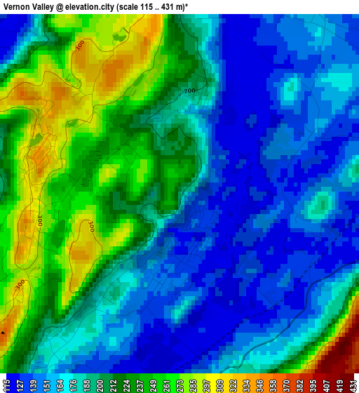
Below is the Elevation map of Vernon Valley, which displays elevation range with different colors. Scale of the first map is from 115 to 431 m (377 to 1414 ft) with average elevation of 196.3 meters (=644 ft) [note 1]
These maps also provides idea of topography and contour of this city, they are displayed at different zoom levels. More info about maps, scale and edge coordinates you can find below images.
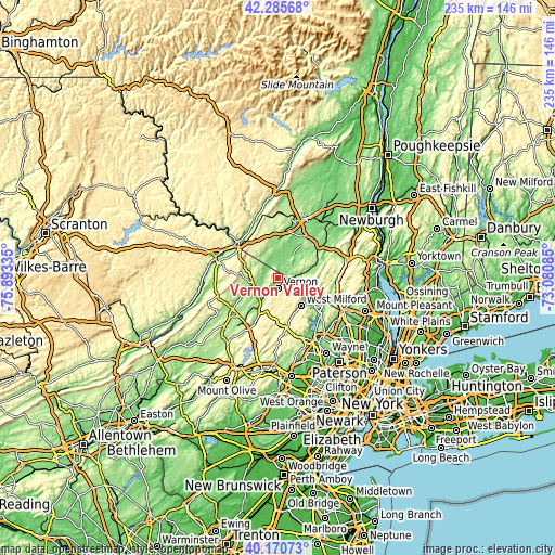
| \ | Map #1 | Topo.Map |
| Scale [m] | 115..431 m | × |
| Scale [ft] | 377..1414 ft | × |
| Average | 196.3 m = 644 ft | × |
| Width | 7.35 km = 4.6 mi | 235.2 km = 146.1 mi |
| Height | 7.35 km = 4.6 mi | 235.2 km = 146.1 mi |
| ↑Max Latitude | 41.269798° | 42.28568° |
| Latitude at center | 41.23676° | 41.23676° |
| ↓Min Latitude | 41.203705° | 40.17073° |
| ← Min Longitude | -74.531045° | -75.89335° |
| Longitude center | -74.4871° | -74.4871° |
| →Max Longitude | -74.443155° | -73.08085° |
Nearby cities:
Cities around Vernon Valley sort by population:
• West Milford elevation 214 m
15.4 km,  139°
139°
• Warwick 160 m
10.9 km,  78°
78°
• Highland Lake 376 m
7.1 km,  159°
159°
• Franklin 186 m
15 km,  211°
211°
• Chester 145 m
22.8 km,  52°
52°
• Eden 122 m
5.8 km,  354°
354°
• Hamburg 142 m
11.9 km,  218°
218°
• Greenwood Lake 194 m
16.2 km,  95°
95°
• Florida 139 m
15.2 km, 45°
• Ogdensburg 205 m
19.4 km, 207°
• Sussex 138 m
10.5 km,  253°
253°
• Vernon Center 204 m
5.5 km,  194°
194°
Multilingual:
 En español:
Vernon Valley elevación 198 m.
 En France:
Vernon Valley élévation 198 m.
 Auf Deutsch:
Vernon Valley höhe über dem Meeresspiegel ist 198 m.

Sources and notes:
- [note 1] Map square and city borders are not equal. Map elevation data is calculated only from area inside that square.
- [src 1] Elevation data from geonames database provided with same terms of usage.
- [src 2] The elevation map of Vernon Valley is generated using elevation data from NASA's 3 arcsec (90m) resolution SRTM data.
- [src 3] Base (background) map © OpenStreetMap contributors tiles are generated by Geofabrik and OpenTopoMap.
Copyright & License:
This Vernon Valley Elevation Map is licensed under CC BY-SA. You may reuse any part from this page, if you give a proper credit by linking to this URL:
 More info on terms of use page.