Kerhonkson elevation
Kerhonkson (New York, Ulster County), United States elevation is 82 meters and Kerhonkson elevation in feet is 269 ft above sea level [src 1]. Kerhonkson is a populated place (feature code) with elevation that is 197 meters (646 ft) smaller than average city elevation in United States.
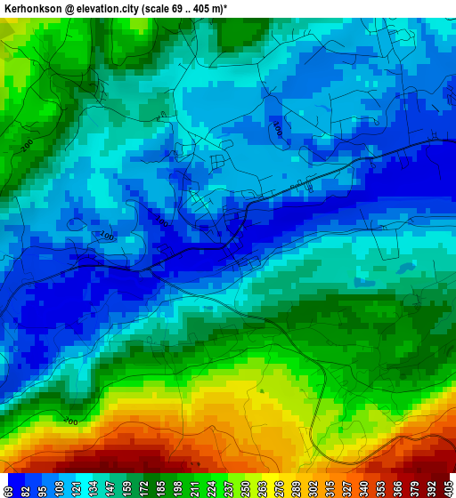
Below is the Elevation map of Kerhonkson, which displays elevation range with different colors. Scale of the first map is from 69 to 405 m (226 to 1329 ft) with average elevation of 163.8 meters (=537 ft) [note 1]
These maps also provides idea of topography and contour of this city, they are displayed at different zoom levels. More info about maps, scale and edge coordinates you can find below images.
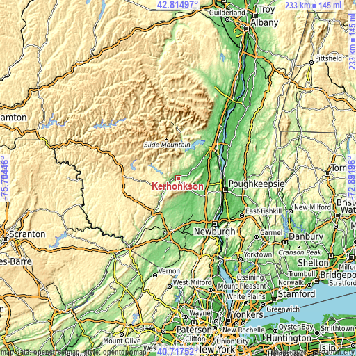
| \ | Map #1 | Topo.Map |
| Scale [m] | 69..405 m | × |
| Scale [ft] | 226..1329 ft | × |
| Average | 163.8 m = 537 ft | × |
| Width | 7.29 km = 4.5 mi | 233.2 km = 144.9 mi |
| Height | 7.29 km = 4.5 mi | 233.2 km = 144.9 mi |
| ↑Max Latitude | 41.807585° | 42.81497° |
| Latitude at center | 41.77482° | 41.77482° |
| ↓Min Latitude | 41.742039° | 40.71752° |
| ← Min Longitude | -74.342155° | -75.70446° |
| Longitude center | -74.29821° | -74.29821° |
| →Max Longitude | -74.254265° | -72.89196° |
Nearby cities:
Cities around Kerhonkson sort by population:
• Wawarsing elevation 91 m
5.2 km,  250°
250°
• New Paltz 76 m
17.8 km,  99°
99°
• Marbletown 68 m
19.5 km,  51°
51°
• Ellenville 105 m
10.3 km,  231°
231°
• Watchtower 109 m
15.6 km,  168°
168°
• Wallkill 88 m
21.1 km,  153°
153°
• Pine Bush 121 m
18.5 km,  180°
180°
• Tillson 73 m
20 km,  72°
72°
• Rosendale Village 50 m
20.4 km, 65°
• Napanoch 104 m
7 km,  240°
240°
• Stone Ridge 111 m
15.8 km,  56°
56°
• Brownville 261 m
7.4 km,  292°
292°
Multilingual:
 En español:
Kerhonkson elevación 82 m.
 En France:
Kerhonkson élévation 82 m.
 Auf Deutsch:
Kerhonkson höhe über dem Meeresspiegel ist 82 m.

Sources and notes:
- [note 1] Map square and city borders are not equal. Map elevation data is calculated only from area inside that square.
- [src 1] Elevation data from geonames database provided with same terms of usage.
- [src 2] The elevation map of Kerhonkson is generated using elevation data from NASA's 3 arcsec (90m) resolution SRTM data.
- [src 3] Base (background) map © OpenStreetMap contributors tiles are generated by Geofabrik and OpenTopoMap.
Copyright & License:
This Kerhonkson Elevation Map is licensed under CC BY-SA. You may reuse any part from this page, if you give a proper credit by linking to this URL:
 More info on terms of use page.