Rosendale Village elevation
Rosendale Village (New York, Ulster County), United States elevation is 50 meters and Rosendale Village elevation in feet is 164 ft above sea level [src 1]. Rosendale Village is a populated place (feature code) with elevation that is 229 meters (751 ft) smaller than average city elevation in United States.
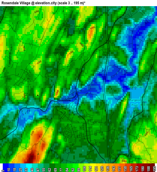
Below is the Elevation map of Rosendale Village, which displays elevation range with different colors. Scale of the first map is from 3 to 195 m (10 to 640 ft) with average elevation of 72.1 meters (=237 ft) [note 1]
These maps also provides idea of topography and contour of this city, they are displayed at different zoom levels. More info about maps, scale and edge coordinates you can find below images.
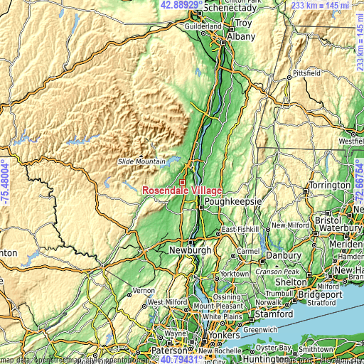
| \ | Map #1 | Topo.Map |
| Scale [m] | 3..195 m | × |
| Scale [ft] | 10..640 ft | × |
| Average | 72.1 m = 237 ft | × |
| Width | 7.28 km = 4.5 mi | 232.9 km = 144.7 mi |
| Height | 7.28 km = 4.5 mi | 232.9 km = 144.7 mi |
| ↑Max Latitude | 41.883106° | 42.88929° |
| Latitude at center | 41.85038° | 41.85038° |
| ↓Min Latitude | 41.817637° | 40.79431° |
| ← Min Longitude | -74.117735° | -75.48004° |
| Longitude center | -74.07379° | -74.07379° |
| →Max Longitude | -74.029845° | -72.66754° |
Nearby cities:
Cities around Rosendale Village sort by population:
• Kingston elevation 63 m
10.6 km,  36°
36°
• New Paltz 76 m
11.5 km,  185°
185°
• Marbletown 68 m
4.9 km,  318°
318°
• Port Ewen 58 m
10.1 km,  52°
52°
• Hurley 62 m
8.3 km,  7°
7°
• Rhinebeck 62 m
15.8 km,  57°
57°
• Lake Katrine 59 m
16.6 km,  25°
25°
• Lincoln Park 56 m
13 km, 30°
• West Hurley 185 m
16.5 km,  351°
351°
• Hyde Park 57 m
13.7 km,  122°
122°
• Tillson 73 m
2.4 km,  169°
169°
• Stone Ridge 111 m
5.4 km,  273°
273°
Multilingual:
 En español:
Rosendale Village elevación 50 m.
 En France:
Rosendale Village élévation 50 m.
 Auf Deutsch:
Rosendale Village höhe über dem Meeresspiegel ist 50 m.

Sources and notes:
- [note 1] Map square and city borders are not equal. Map elevation data is calculated only from area inside that square.
- [src 1] Elevation data from geonames database provided with same terms of usage.
- [src 2] The elevation map of Rosendale Village is generated using elevation data from NASA's 3 arcsec (90m) resolution SRTM data.
- [src 3] Base (background) map © OpenStreetMap contributors tiles are generated by Geofabrik and OpenTopoMap.
Copyright & License:
This Rosendale Village Elevation Map is licensed under CC BY-SA. You may reuse any part from this page, if you give a proper credit by linking to this URL:
 More info on terms of use page.