Hackettstown elevation
Hackettstown (New Jersey, Warren County), United States elevation is 173 meters and Hackettstown elevation in feet is 568 ft above sea level [src 1]. Hackettstown is a populated place (feature code) with elevation that is 106 meters (348 ft) smaller than average city elevation in United States.
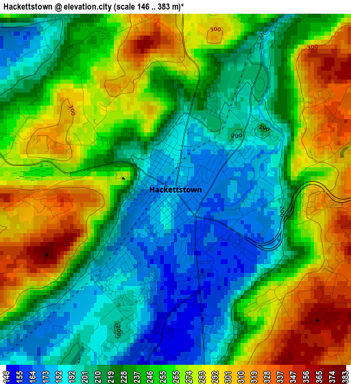
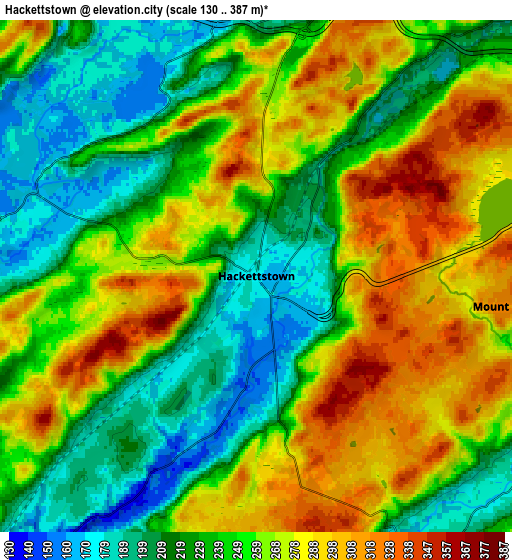
Below is the Elevation map of Hackettstown, which displays elevation range with different colors. Scale of the first map is from 146 to 383 m (479 to 1257 ft) with average elevation of 241.4 meters (=792 ft) [note 1]
These maps also provides idea of topography and contour of this city, they are displayed at different zoom levels. More info about maps, scale and edge coordinates you can find below images.
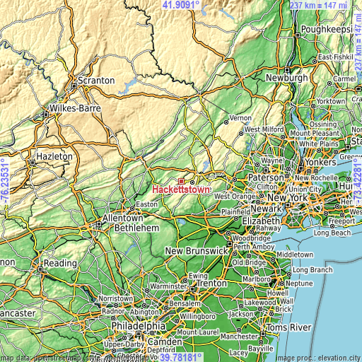
| \ | Map #1 | Map #2 | Topo.Map |
| Scale [m] | 146..383 m | 130..387 m | × |
| Scale [ft] | 479..1257 ft | 427..1270 ft | × |
| Average | 241.4 m = 792 ft | 251.5 m = 825 ft | × |
| Width | 7.39 km = 4.6 mi | 14.78 km = 9.2 mi | 236.5 km = 147 mi |
| Height | 7.39 km = 4.6 mi | 14.78 km = 9.2 mi | 236.5 km = 147 mi |
| ↑Max Latitude | 40.887221° | 40.920435° | 41.9091° |
| Latitude at center | 40.85399° | 40.85399° | 40.85399° |
| ↓Min Latitude | 40.820742° | 40.787478° | 39.78181° |
| ← Min Longitude | -74.873005° | -74.916951° | -76.23531° |
| Longitude center | -74.82906° | -74.82906° | -74.82906° |
| →Max Longitude | -74.785115° | -74.741169° | -73.42281° |
Nearby cities:
Cities around Hackettstown sort by population:
• Hopatcong Hills elevation 346 m
16.7 km,  53°
53°
• Succasunna 223 m
15.9 km,  84°
84°
• Budd Lake 291 m
8.2 km, 76°
• Washington 143 m
16.5 km,  229°
229°
• Landing 286 m
14.9 km,  67°
67°
• Beattystown 152 m
4.7 km,  194°
194°
• Stanhope 262 m
11.5 km,  61°
61°
• Netcong 267 m
11.5 km, 64°
• Long Valley 165 m
8.6 km,  151°
151°
• Chester 260 m
13.6 km,  124°
124°
• Oxford 174 m
14.6 km,  247°
247°
• Califon 152 m
15 km,  182°
182°
Multilingual:
 En español:
Hackettstown elevación 173 m.
 En France:
Hackettstown élévation 173 m.
 Auf Deutsch:
Hackettstown höhe über dem Meeresspiegel ist 173 m.

Sources and notes:
- [note 1] Map square and city borders are not equal. Map elevation data is calculated only from area inside that square.
- [src 1] Elevation data from geonames database provided with same terms of usage.
- [src 2] The elevation map of Hackettstown is generated using elevation data from NASA's 3 arcsec (90m) resolution SRTM data.
- [src 3] Base (background) map © OpenStreetMap contributors tiles are generated by Geofabrik and OpenTopoMap.
Copyright & License:
This Hackettstown Elevation Map is licensed under CC BY-SA. You may reuse any part from this page, if you give a proper credit by linking to this URL:
 More info on terms of use page.